
Country India Headquarters Palakkad Website www.palakkad.nic.in Population 2.811 million (2011) | State Kerala Time zone IST (UTC+5:30) Literacy 94.5% ISO 3166 code ISO 3166-2:IN | |
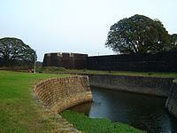 | ||
Vehicle registration Palakkad KL-09,Alathur KL-49,Mannarkkad KL-50,Ottappalam KL-51,Pattambi KL-52,Chittur KL-70 Colleges and Universities Government Victoria College, Palakkad Points of interest Palakkad Fort, Pothundi Dam, Fantasy Park, Malampuzha Dam, Malampuzha Gardens Destinations Palakkad, Nelliampathi, Parambikulam Wildlife S, Malampuzha, Attappadi | ||
Top 5 travel attractions palakkad district kerala tourism
Palakkad District is one of the 14 districts of the Indian state of Kerala. The city of Palakkad is the district headquarters. Palakkad is bordered on the northwest by the Malappuram District, on the southwest by the Thrissur District, on the northeast by The Nilgiris District and on the east by Coimbatore district of Tamil Nadu. The district is 24.4% urbanised according to the census of 2011. The district is nicknamed "the granary of Kerala" and "Rice bowl of Kerala".
Contents
- Top 5 travel attractions palakkad district kerala tourism
- Map of Palakkad Kerala
- Name
- Administration
- Economy
- Demographics
- Languages
- Noted personalities
- Transport
- Education In Palakkad
- Tourist attractions
- Satellite Images
- References
Map of Palakkad, Kerala
Name
In earlier times, Palakkad was also known as Palakkattussery.
Palakkad is the gateway to Kerala due to the presence of the Palakkad Gap, in the Western Ghats. The total area of the district is 4,480 km2 (1,730 sq mi) which is 11.5% of the state's area. Out of the total area of 4,480 km2 (1,730 sq mi), about 1,360 km2 (530 sq mi) of land is covered by forests. Most parts of the district fall in the midland region (elevation 75–250 m or 246–820 ft), except the Nelliampathy-Parambikulam area in the Chittur taluk in the south and Attappadi-Malampuzha area in the north, which are hilly and fall in the highland region (elevation > 250 m or 820 ft).
The climate is pleasant for most part of the year, exception is on the summer months. There is sufficient rainfall and it receives more rainfall than the extreme southern districts of kerala. The district is blessed with many small and medium rivers, which are tributaries of the Bharathapuzha River. A number of dams have been built across these rivers, the largest being Malampuzha dam. The largest in volume capacity is the Parambikulam Dam
Administration
Economy
IIT Palakkad for Kerala started operations in its temporary campus at Kanjikode, Palakkad from 3 August 2015. Many industries are located in the Kanjikode Industrial Area, which is termed as the second biggest industrial area in Kerala, many central government institutions are located in this area Palakkad is the first paperless revenue district by computerizing the collectorate, five taluks and 156 village offices. It became the first computerized collectorate in the country implemented under the ‘DC Suit’ system and the first district where all the five taluk offices are computerized under the ‘Taluk Suit’ and connected with the Collectorate. There are various industries in the district. The Public Sector companies and Instrumentation Limited have plants in Kanjikode, 12 kilometres (7.5 miles) from Palakkad town. Other large companies are the BPL group, Coca-Cola and Pepsi. There is an Industrial Area in Kanjikode with a number of medium industries. Palakkad is the one of the most agrarian districts in Kerala. Palakkad is particularly known for paddy cultivation. Paddy is cultivated in around 83,998 Hectares in the district and occupies the first position in the production of rice in the state. Palakkad also occupies the first position in the state for the production of groundnut, tamarind, turmeric, tuber, vegetables, pulses, mango, banana, plantain and cotton. Rubber, coconut, areca nut, black pepper, etc. are also cultivated extensively like other parts of Kerala.
Demographics
According to the 2011 census Palakkad district has a population of 2,810,892, roughly equal to the nation of Jamaica or the US state of Utah. This gives it a ranking of 138th in India (out of a total of 640). The district has a population density of 627 inhabitants per square kilometre (1,620/sq mi). Its population growth rate over the decade 2001–2011 was 7.39%. Palakkad has a sex ratio of 1067 females for every 1000 males, and a literacy rate of 89.32%. Palakkad city has a literacy rate of 94.20%
Languages
The official language Malayalam is predominantly and widely spoken in the district, while Tamil forms the main language of over 6% of the district's population.
Noted personalities
Transport
Palakkad town consists of two railway stations namely Palakkad Town railway station and Palakkad Junction Railway station. Palakkad Junction is an important station on the Southern Railway.The office of the Palakkad Division of the Southern Railway is situated near Palghat Junction Railway Station. The trains coming from Other parts of India are diverted to north and south Kerala from Shoranur Junction in Palakkad District. From here there is train service to Calicut, Ernakulam, Trivandrum, Shoranur and Nilambur. Shoranur Junction also has rail connections to Mangalore and the Konkan Railway, enabling travel towards Goa and Bombay.
Palakkad has a medium grade network of roads. The Salem-Kanyakumari National Highway 47 and the Palakkad-Kozhikode National Highway 213 run through the district. Another important road is the Palakkad – Ponnani road which connects NH 47 and NH 17.
The nearest Airport is at Coimbatore (Coimbatore International Airport) which is 60 kilometres (37 miles) from the City.The Calicut International Airport is 103 kilometres (64 miles) from Palakkad City,and Cochin International Airport is 111 kilometres (69 miles) from the city, it offers connections to all parts of India and a few international destinations. Air India, SpiceJet, JetLite (now Jet Konnect), Kingfisher Airlines (suspended as of Oct 2012), Goair, Paramount airways, Air Arabia and Air India are the major operators.