
Time zone EET (UTC+2) Vehicle registration Z Local time Tuesday 4:46 AM | Elevation 6 m (20 ft) Postal code 190 xx Website www.palaiafokaia.gr Area code 22910 | |
 | ||
Weather 12°C, Wind NW at 3 km/h, 80% Humidity | ||
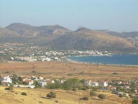
Palaia Fokaia (Greek: Παλαιά Φώκαια, meaning Old Phocaea) is a former community and a seaside town in East Attica, Greece. Since the 2011 local government reform it is part of the municipality Saronikos, of which it is a municipal unit. The municipal unit has an area of 22.944 km2. Its population was 3,436 at the 2011 census.
Contents
Map of Palaia Fokaia 190 13, Greece
Geography
Palaia Fokaia is located on the Saronic Gulf coast, in the southeastern part of the Attica peninsula. There are low mountains south and east of the town. It lies 2 km south of Anavyssos, 9 km west of Lavrio and 36 km southeast of Athens city centre. Greek National Road 91 (Athens - Sounio) passes through the town.
The municipal unit includes the village of Thymari (pop. 723) and the small, rocky and deforested island of Patroklos, which is uninhabited.