
Country Thailand Postal code 80140 Area 422.5 km² | Time zone THA (UTC+7) Geocode 8012 | |
 | ||
Seat Pak Phanang Fang Tawan-ok Province Nakhon Si Thammarat Province | ||
Pak Phanang (Thai: ปากพนัง) is a district (Amphoe) of Nakhon Si Thammarat Province, southern Thailand.
Contents
Map of Pak Phanang District, Nakhon Si Thammarat, Thailand
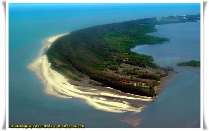
The name of district means Sheltered Mouth, referring to the mouth of the Pak Phanang river protected from the open sea by a long peninsula.
History
During the thesaphiban administrative reforms the district was created in 1895 in the name Bia Sad (เบิ้ยซัด). On March 22, 1903 it was renamed to Pak Phanang, a name first recorded for the area in 1665.
On October 25, 1962 Tropical Storm Harriet hit the district. The low Talumphuk peninsula to the north of the district was completely devastated, and even in the town Pak Phanang itself the storm surge made the water rise to 4 meter depth. The flooding caused more than 1000 fatalities, and many more homeless.
Geography
Neighboring districts are (from the south clockwise) Hua Sai, Chian Yai, Chaloem Phra Kiat and Mueang Nakhon Si Thammarat. To the east is the Gulf of Thailand.
The most striking geographical feature is the long elongated peninsula Talumphuk, which is formed of sand deposited by the predominantly northward current interacting with the outflow of the Pak Phanang River (Thai: แม่น้ำปากพนัง). The shallow bay formed by the peninsula is about 3 km wide at the mouth of the river and 10 km at the top of the peninsula. Originally the coastline of the bay consisted of tidal flats and mangrove forests, however a lot of the western coast had been converted into shrimp farms.
Administration
The district is subdivided into 18 subdistricts (tambon), which are further subdivided into 133 villages (muban). Pak Phanang is a town (thesaban mueang) which covers the whole tambon Pak Phanang and parts of tambon Hu Long, Pak Phanang Fang Tawan Tok, Pak Phanang Fang Tawan Ok and Bang Phra. There are further 17 Tambon administrative organizations.