
Elevation 960 m | ||
 | ||
Location Lautém District, East Timor | ||
Paitchau (also Gunung Paitchau, or Paitchao, or Paitxau; locally, Pai Tekau Ile) is a mountain in the Tutuala subdistrict, Lautém District of East Timor. Situated within Nino Konis Santana National Park, it is south of Lake Ira Lalaro. Though part of a mountain chain, Paitchau is an isolated mountain in the southern Sucos Mehara. It ranges in altitude from 0–960 metres (0–3,150 ft). BirdLife International has classified the mountain and its surrounding region of 55,797 hectares (137,880 acres) as an Important Bird Area of East Timor. The area contained within the Paitchau Range and Ira Lalaro is sparsely populated and contains several unique faunal and floral species.
Contents
Map of Paitchau, Timor-Leste
Geography
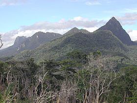
Paitchau is a sharp peak, prominent from the southwest. The hill range is located in the extreme eastern part of Timor-Leste and it slopes towards the coastline of Lore and Silvicola which have coral reefs. The area is thinly populated and has diverse flora and fauna. Its slopes are steep and the southern part of the range towards the coast is thickly forested. The range rises to a maximum height of 960 metres (3,150 ft) or 1,030 metres (3,380 ft) and is made up of massive primary karst limestone formations.
Flora and fauna
Paitchau is characterized by tropical moist deciduous lowland forest and tropical mixed evergreen forest. There is swamp land around Ira Lalaro. Paitchau is said to contain "the best remaining 'primary’ forest" in the country.
Fauna
There are 24 restricted-range species (listed below) in the Important Bird Area which includes the endangered Treron psittaceus (Timor green-pigeon), and the critically endangered Cacatua sulphurea (yellow-crested cockatoo).