
Elevation 699 m (2,293 ft) Area 66.44 km² Local time Monday 4:40 PM | Frazioni Ascolese, Caiazzano Demonym(s) Padulesi Dialling code 0975 | |
 | ||
Weather 16°C, Wind SW at 8 km/h, 73% Humidity Points of interest Certosa di Padula, Museo archeologico provincial, Casa Museo Joe Petrosino, Museo Civico Multimedi | ||
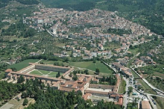
Padula is a comune in the province of Salerno in the Campania region of south-western Italy. It is the home of the Carthusian monastery Certosa di San Lorenzo, sometimes referred to as the Certosa di Padula. As of 2011 its population was of 5,279.
Contents
- Map of 84034 Padula Province of Salerno Italy
- Geography
- History
- Religious Monuments and Churches
- Famous residents
- Transport
- Festivals and Events
- References
Map of 84034 Padula Province of Salerno, Italy
Geography
It is located about 100 kilometres south-east of the provincial capital of Salerno. The majority of the town is on a hillside that reaches 698 meters above sea level. The comune covers an area of 66.33 square kilometres.
History
Its existence reaches back to at least the ninth century when local people used the hilltop area for defence against the Saracens. The history of Padula as an organized village begins with the arrival in 1296 of Tommaso II Sanseverino, though the Monastery of Saint Nicola had been erected on this site earlier, in 1086. This name was chosen because of the legendary man known as Padula.
Religious Monuments and Churches
Famous residents
Transport
The town counts a railway station on the abandoned Sicignano-Lagonegro line, closed in 1987. It is served by the A3 motorway Naples-Reggio Calabria, at the exit "Padula-Buonabitacolo", which is the northern end of a highway to Policastro Bussentino on the Cilentan Coast. Nearest airports are Salerno-Pontecagnano (97 km far) and Naples-Capodichino (168 km).