
Local time Monday 2:36 PM | Unitary authority | |
 | ||
Weather 9°C, Wind W at 24 km/h, 66% Humidity | ||
The haunted iron bridge of padgate warrington
Padgate is a suburb of the English town and unitary authority of Warrington, Cheshire. It belongs to the civil parish of Poulton-with-Fearnhead.
Contents
- The haunted iron bridge of padgate warrington
- Map of Padgate Warrington UK
- Overview
- RAF Station
- Geography
- Main sights
- Transport
- References
Map of Padgate, Warrington, UK
Overview
Historically part of Lancashire, in the centre of Padgate, next to the railway line, is a large area of land and playing fields known as Bennett's Recreation Ground or simply Bennett's Rec. This was the home of the Woolston Rovers rugby league side and also the Cheshire Cadets Drum and Bugle Corps with their headquarters Kennedy Hall. Following a fire at the club house/bar, the club struggled to survive. Recently a new changing room facility has been built on the site of the former club house and the club is starting to rebuild. This is also home to Greenall's Padgate St Oswald's reserves football team who are currently competing in the Mid Cheshire Football League reserve division. Greenall's Padgate St Oswald's first team play at Tetley Walker's Club, Long Lane, Warrington.
RAF Station
During World War II, it had a small RAF Station. RAF Padgate will be well-remembered by thousands of young men who were selected for RAF national service and on this site received their first taste of military discipline, ill-fitting uniforms and a severe haircut.
The site of the former RAF station is now largely covered by a housing estate, bordered by various other local amenities and suburbs of Warrington - Bennett's Rec (where the Cheshire Cadets Drum and Bugle Corps are based) and the railway line to the south, Fearnhead to the North-East, Blackbrook and Cinnamon Brow to the northern side. University Academy Warrington (a secondary school, originally known as Padgate High School and then renamed as Lysander Community High School) is also sited on this land.
The university campus (which despite being known as 'the Padgate Campus' is in fact in the neighbouring village of Fearnhead) belonging to the University of Chester was used as a camp for Canadian servicemen during the Second World War, before becoming a teacher training college in 1946. The campus is home to 384 students. A variety of degree courses are on offer, including degrees in journalism and sport-related subjects. The campus houses a SU bar named bar twenty ten. There are 8 halls of residence and also a cul-de-sac called College Close.
Geography
Located east of Warrington centre (4 kilometres (2.5 mi) far), Padgate lies in the middle of the urban areas of Liverpool and Manchester. It is 32 kilometres (20 mi) east of Liverpool, 44 kilometres (27 mi) west of Manchester, and 38 kilometres (24 mi) northeast of Chester. The suburb is crossed to the south by the river Mersey and is not too far from the Manchester Ship Canal.
Main sights
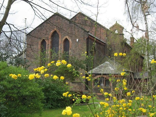
Its parish church, Christ Church (1838), is a listed building, the vicarage associated with the church is locally listed. Christ Church has an affiliated Church of England Primary School nearby. There are two other churches in the area: Padgate Methodist Church and St. Oswalds Roman Cathlolic church.
Transport
Padgate has an unmanned railway station on the Manchester-Liverpool line served by the local stopping service. The M6 motorway is located some km east, and nearest exit is "Warrington-Irlam-A57". The A roads serving Padgate are the A50, A57 and A574.