
Sovereign state United Kingdom Postcode district CT18 | Local time Monday 1:54 PM District Shepway | |
 | ||
Population 38 (parish, 2001 Census) Weather 9°C, Wind SW at 35 km/h, 90% Humidity | ||
Paddlesworth is a village located about 3 miles (4.8 km) NNW of Folkestone in Kent, England, near Hawkinge.At the 2011 Census the population was included in the town of Hawkinge.
Map of Paddlesworth, Folkestone, UK
Paddlesworth was a sighting-point for the Anglo-French Survey (1784–1790) linking the Royal Greenwich Observatory with the Paris Observatory, undertaken by General William Roy. A chain of readings was made from high points between the two observatories, including locally from Dover Castle, St Peter's Church, Swingfield, and Aldington Knoll.
The Early Norman Anglican parish church is dedicated to St Oswald. It was built in the 11th century or earlier but underwent alteration in the 13th and restoration in the 19th century. It has been designated as a Grade I listed building.
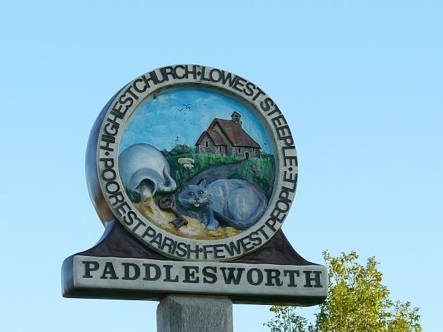
It is said of Paddlesworth that it has the "Highest Church, Lowest Steeple, Poorest Parish, Fewest People". These words can be seen carved in a circle round the edge of the village sign, as seen in the above photograph.
The public house is 'The Cat and Custard Pot'.
From September to December 2010 a group of writers and artists created the Paddlesworth Press, a "mixed-media, collaborative online novel" based on Paddlesworth with fictional characters and events in a spoof newspaper.