
Founded January 2, 1857 Time zone PET (UTC-5) Elevation 3,292 m | Region Ancash Capital Pacllón UBIGEO 020513 Area 212 km² | |
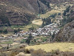 | ||
Pacllón is a district of the province of Bolognesi, in the Ancash Region of Peru.
Contents
Map of Pacll%C3%B3n District, Peru
The town is within a day's walk from Chiquián. Many of the arrierros (donkey owners) that work in Waywash live here. Donkeys can be obtained here. The town is also home to stores with a regular selection of meals.
The hike from either the lake Hawaqucha or the Jashapampa valley takes all day and offers some of the best views of the Waywash mountain range. There are places to camp on both sides of the town.
Mountains
The Waywash range is the natural eastern and southeastern border of the district. The highest peak of the district is Yerupajá which is also the highest elevation of the range at6,635 m (21,768 ft). Other mountains of the district are listed below:
References
Pacllón District Wikipedia(Text) CC BY-SA