
Traversed by SR 152 Elevation 396 m | Reference no. 829 | |
 | ||
Similar | ||
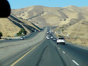
Pacheco Pass, elevation 1,368 ft (417 m), is a mountain pass located in the Diablo Range in southeastern Santa Clara County, California. It is the main route through the hills separating the Santa Clara Valley and the Central Valley.
Contents
- Map of Pacheco Pass California 95023 USA
- NamesEdit
- HistoryEdit
- Nearby featuresEdit
- California High Speed RailEdit
- References
Map of Pacheco Pass, California 95023, USA
As with most passes in the California Coast Ranges, it is not very high when compared to those in other mountain areas within the state. The road that traverses Pacheco Pass is State Route 152, which runs for 106 miles (171 km) between SR 1 in Watsonville and SR 99. Pacheco Pass Road, the western section between Gilroy and the pass itself (a distance of approximately 14 miles), is single-lane state highway in each direction and is the site of many accidents.
NamesEdit
The pass was named for Francisco Perez Pacheco of the Rancho Ausaymas y San Felipe. In the 1850s, an informal variant name for the pass was Robber's Pass attributed to the frequent hold-ups experienced by travelers using the route.
HistoryEdit
A trail nearby, through what is now Pacheco State Park, was used by the Yokuts people to cross the mountains and trade with other native people on the coast. Spanish army officer Gabriel Moraga first recorded the pass in 1805. Since then, it has been a major route between the Santa Clara Valley and the Central Valley. It was the site of one of the stage stations on the route of the Butterfield Overland Mail stagecoach route which connected the Saint Louis, Missouri with San Francisco from 1858 until 1861. Other stage lines used the route thereafter until completion of the railroads within the state.
Pacheco Pass is registered as California Historical Landmark #829.
Nearby featuresEdit
There are no major communities between Gilroy in the Santa Clara Valley and Los Banos in the Central Valley. There are no other major crossings of the Diablo range farther south until they are crossed again by California State Route 198 at an unnamed pass some 75 miles (121 km) to the south.
On the west side of the pass lies Casa de Fruta, an extensive trading post in the valley of Pacheco Creek. Originally a site devoted to selling locally produced fruit and nuts to travelers, Casa de Fruta has expanded to include a delicatessen, truckstop, RV park, and other facilities. A rural locale named Bell Station also lies along the route, between Casa de Fruta and the pass.
On the eastern slope of the pass lies the San Luis Reservoir, which stores water for the Central Valley Project and the California State Water Project. The San Luis Reservoir and O'Neill Forebay operate as a pumped storage hydroelectric plant. The roadway entrances to the San Luis Reservoir state recreational area and Pacheco State Park require caution entering or exiting because there are no stop signs or traffic lights and two lanes of heavy traffic in each direction.
Pacheco State Park extends to the south of the pass from its entrance on Dinosaur Point Road near the pass. There is a small windfarm located at the top of the pass that can be seen from Dinosaur Point Road.
The Pacheco Pass American Viticultural Area is nearby.
California High-Speed RailEdit
Pacheco Pass has been tentatively selected as the route that the proposed California High-Speed Rail will take between the Bay Area and the Central Valley.