
Country Peru Founded January 2, 1857 Subdivisions 11 populated centers Elevation 75 m Province Lima District | Region Lima Capital Pachacamac Time zone PET (UTC-5) Area 160.2 km² | |
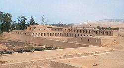 | ||
The Pachacamac District is one of 43 districts of the Lima Province in Peru. The capital of the district is the village of Pachacamac. Its main asset is the archaeological Inca site Pachacamac.
Contents
Map of Pachacamac District, Peru
History
Pachacamac was first encountered by Hernándo Pizarro on January 30, 1530 while on his quest for gold and his search for a location of a new capital. In 1573 the city of Santísimo Salvador de Pachacámac was founded. In 1857, Pachacamac was founded as a republican district.
Location
The district is located in the southern part of the Lima province at an elevation of 75m.
Political division
The district is divided into 11 populated centers (Spanish: Centros Poblados):
Capital
The capital of the Pachacamac district is the village of Pachacamac.
References
Pachacamac District Wikipedia(Text) CC BY-SA