
Country Thailand Postal code 14130 Area 80.9 km² Province Ang Thong Province | Time zone THA (UTC+7) Geocode 1503 Population 28,140 (2000) | |
 | ||
Pa Mok (Thai: ป่าโมก) is the southernmost district (Amphoe) of Ang Thong Province, central Thailand.
Contents
Map of Pa Mok District, Ang Thong, Thailand
History
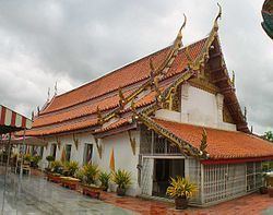
This area was called Ban Pa Mok Noi. In 1585 King Naresuan the Great set his military camp in the area. Before moving his troops to fight with Burmese troops of Phra Maha Uparacha at Don Chedi, he saluted the big Reclining Buddha in Pa Mok. And he won the war. During the reign of King Thai sa, he was the leader of workers who moved the Reclining Buddha to save it from flooding.
Pa Mok district was separated from Mueang Ang Thong district and upgraded to a full district in 1902. The first district office was finished in 1904.
Geography
Neighboring districts are (from the north clockwise) Wiset Chai Chan and Mueang Ang Thong of Ang Thong Province, and Maha Rat, Bang Pahan, Bang Ban and Phak Hai of Ayutthaya Province.
Administration
The district is subdivided into 8 subdistricts (tambon). The township (thesaban tambon) Pa Mok covers the complete tambon Pa Mok and Bang Pla Kot.