
Surface area 7,787 acres (3,151 ha) Area 31.51 km² Length 12.87 km | Max. depth 331 ft (101 m) Surface elevation 8.8 m Width 4.828 km | |
 | ||
Islands Baby Island, Garden Island, Tivoli Similar Rialto Beach, Lake Crescent, Ruby Beach, Hurricane Ridge, Hoh Rainforest | ||
Ozette Lake is the largest unaltered natural lake in Washington state at 29.5 km² (2,954 ha).
Map of Ozette Lake, Washington 98326, USA
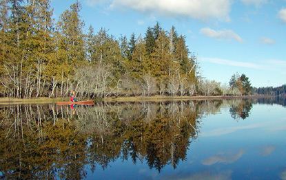
The Makah name for Lake Ozette was Kahouk meaning "large lake." Eight miles long and three miles wide, Ozette Lake is contained within the northern boundary of the Olympic National Park's coastal strip. It is 29 feet (~9 m) above sea level and is drained by the Ozette River in the north end. Ozette, Washington lies at the north end of the lake. At 331 feet deep, its bottom lies more than 300 feet below sea level.
There are three islands on Ozette Lake: Tivoli, Garden Island, and Baby Island. Tivoli's sandy shore is a favorite kayaking and canoeing destination for overnight tent campers willing to make the long trip down the lake. Beware of unpredictable weather conditions, as the large surface of the lake is known to fetch large waves rather quickly. The Erickson's Bay campground is the only boat in campground in Olympic National Park.
Ozette Lake features several trails leading to the Pacific Coast Marine Sanctuary. Three of these trails are continuous cedar boardwalks maintained by the Olympic National Park Service. The two most traveled trails depart from the Olympic National Park information kiosks and restrooms at the north end of Ozette Lake. The northern trail, (3.2 miles,) is a cedar boardwalk leading to Cape Alava, passing through the beautiful Ahlstrom's Prairie; the southern boardwalk trail, (3.3 miles,) leads to Sand Point and the Ozette Indian Petroglyphs at Wedding Rock. (54 petroglyphs.) There is a shorter, (2.5 miles,) boat-in only, well-maintained trail that heads out to the wild ocean beaches from Erickson's Bay, on the northwestern side of Ozette Lake. Additional camping at Erickson's Bay, Eagle Point, or Tivoli Island is available for boaters. Longer coastal hiking trails include the Ozette Loop, connecting the Sand Point and Cape Alava trails by hiking up or down the beach to the next trail head. (About 9 miles.)
Two other trails are known to locals and Scout groups; one heading to the beach just south of the Park-maintained trail from Erickson's, (Coast Guard Trail,) and a trail from Allen's Bay out to Kayostla Beach. Both trails are undeveloped, known to be frequently muddy, and are recommended for more experienced hikers prepared for wet, wilderness hiking.
The National Park Service maintains 15 sites at the main campground at the north end of the lake.