
Range Steenberg Elevation 315 m | Topo map 3418AB Traversed by M64 | |
 | ||
Similar Chapman's Peak, Constantiaberg, Steenberg, Elephant's Eye Cave, Table Mountain National | ||
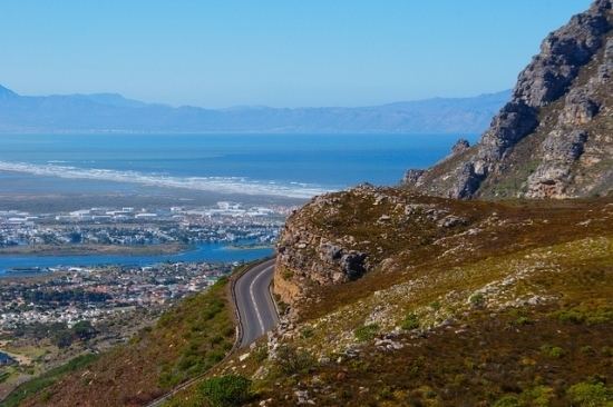
Ou kaapse weg cape town an aerial view
Ou Kaapse Weg (Afrikaans for Old Cape Way), numbered as route M64, is a mountain pass in the Cape Peninsula that connects the Southern Suburbs of Cape Town with the Fish Hoek Valley. It traverses the Steenberg mountains and passes through the Silvermine Nature Reserve. Ou Kaapse Weg is one of three routes to the Fish Hoek Valley: the others are Chapman's Peak Drive along the Atlantic coast and Main Road along the False Bay coast. Despite its name, the pass was only constructed in 1968, by the Divisional Council of the Cape.
Contents
- Ou kaapse weg cape town an aerial view
- Map of Ou Kaapse Weg Silver Mine Nature Reserve Cape Town South Africa
- Ou kaapse weg m64 v3 2016 mountain passes of south africa
- References
Map of Ou Kaapse Weg, Silver Mine (Nature Reserve), Cape Town, South Africa
Ou Kaapse Weg begins at a T-junction with Steenberg Road in Westlake, close to the southern end of the M3 expressway. It rapidly ascends the northern face of the Steenberg mountains, through two hairpin bends, to the summit at an elevation of 315 metres (1,033 ft). Near to the summit are entrance gates to the Silvermine Nature Reserve. The pass then descends along the valley of the Silvermine River, passing by Noordhoek to end at a junction with Kommetjie Road, which provides access to Kommetjie, Fish Hoek and other places in the Fish Hoek Valley.
In 2012 Ou Kaapse Weg suffered severe traffic congestion because it was used as an alternative route to avoid construction work on Main Road between Muizenberg and Fish Hoek.