
Population 356 (2011) Sovereign state United Kingdom Local time Tuesday 12:17 AM | OS grid reference ST225145 Dialling code 01823 | |
 | ||
Weather 6°C, Wind E at 11 km/h, 85% Humidity | ||
Otterford is a village and civil parish in Somerset, England. It is situated on the Blackdown Hills, 7 miles (11.3 km) south of Taunton in the Taunton Deane district. The village has a population of 356.
Contents
Map of Otterford, UK
The River Otter rises close to Otterford.
History
A series of round barrows on Brown Down are known as Robin Hood's Butts.
The village was named Oteriford in a Taunton charter of 854 by King Æthelwulf of Wessex.
The parish of Otterford was part of the Taunton Deane Hundred.
Governance
The parish council has responsibility for local issues, including setting an annual precept (local rate) to cover the council’s operating costs and producing annual accounts for public scrutiny. The parish council evaluates local planning applications and works with the local police, district council officers, and neighbourhood watch groups on matters of crime, security, and traffic. The parish council's role also includes initiating projects for the maintenance and repair of parish facilities, as well as consulting with the district council on the maintenance, repair, and improvement of highways, drainage, footpaths, public transport, and street cleaning. Conservation matters (including trees and listed buildings) and environmental issues are also the responsibility of the council.
The village falls within the Non-metropolitan district of Taunton Deane, which was formed on 1 April 1974 under the Local Government Act 1972, having previously been part of Taunton Rural District. The district council is responsible for local planning and building control, local roads, council housing, environmental health, markets and fairs, refuse collection and recycling, cemeteries and crematoria, leisure services, parks, and tourism.
Somerset County Council is responsible for running the largest and most expensive local services such as education, social services, libraries, main roads, public transport, policing and fire services, trading standards, waste disposal and strategic planning.
It is also part of the Taunton Deane county constituency represented in the House of Commons of the Parliament of the United Kingdom. It elects one Member of Parliament (MP) by the first past the post system of election, and part of the South West England constituency of the European Parliament which elects seven MEPs using the d'Hondt method of party-list proportional representation.
Religious sites
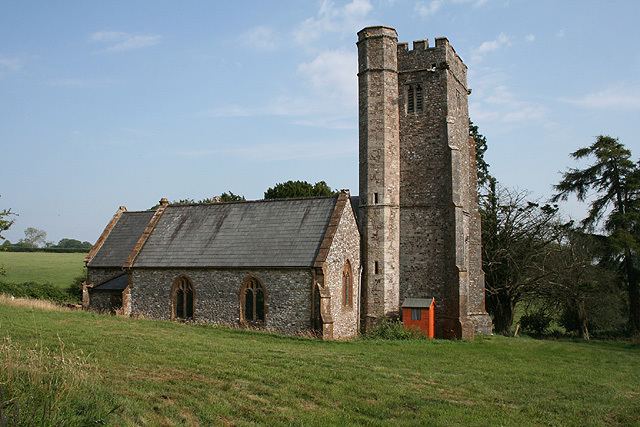
The parish Church of St Leonard dates from the 14th century, but was restored, the nave wall rebuilt and the north aisle added in 1860, with further restoration taking place in 1924.