
Country United States County Franklin Elevation 902 ft (275 m) Zip code 66067 Local time Monday 5:46 PM | Founded 1865 Time zone CST (UTC-6) Population 12,482 (2013) | |
 | ||
Weather 13°C, Wind N at 14 km/h, 73% Humidity Colleges and Universities Ottawa University, Mary Grimes School of Nursing | ||
Advantage ford ottawa kansas the best place to buy your next vehicle
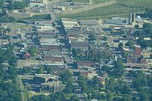
Ottawa is a city in, and the county seat of, Franklin County, Kansas, United States. It is situated along the Marais des Cygnes River. As of the 2010 census, the city population was 12,649
Contents
- Advantage ford ottawa kansas the best place to buy your next vehicle
- Map of Ottawa KS 66067 USA
- Welcome to 635 n cedar in ottawa kansas
- History
- Geography
- Climate
- 2010 census
- 2000 census
- Economy
- Government
- Education
- Newspapers
- Radio
- Entertainment
- Notable people
- References
Map of Ottawa, KS 66067, USA
Welcome to 635 n cedar in ottawa kansas
History
The town grew up around Ottawa Indian settlements. The tribe lived in the area from 1837 to 1867 and donated land for Ottawa University. The town and university were named for the tribe.
The first white permanent settler built his house at Ottawa in 1864.
The city of Ottawa has a history of flooding due to the Marais Des Cygnes river. One of the first major floods which was noted happened in 1844, twenty years before the city's founding in 1864. No official measurements were taken, though was estimated to be at 40 feet (12 m). A flood in 1928 had a crest point of 38.65 ft. in which six people died. Other flood years include 1904, with a crest of 35.8 feet (10.9 m); 1909, cresting at 36.3 feet (11.1 m); 1915, cresting at 31 feet (9.4 m), and 1944 cresting at 36.5 feet (11.1 m).
However, it is the Great Flood of 1951 which is the most famous. It was about five inches higher than the 1928 flood. The flood of 1951 affected much of Missouri and Kansas and 41 people died. One-third of Ottawa was covered because of this flood.
It is unlikely Ottawa will suffer major damage due to a flood again thanks to a series of levees and pumping stations built by the U.S. Army Corps of Engineers in the 1960s, which is part of a larger system of flood systems to regulate the Marais Des Cygnes River to the Missouri River. The levees built along the river are inspected on an annual basis to insure their quality.
In 1943, German and Italian prisoners of World War II were brought to Kansas and other Midwest states as a means of solving the labor shortage caused by American men serving in the war. Large internment camps were established in Kansas: Camp Concordia, Camp Funston (at Fort Riley), Camp Phillips (at Salina under Fort Riley). Fort Riley established 12 smaller branch camps, including Ottawa.
Geography
Ottawa is located at 38°36′43″N 95°15′59″W (38.612044, -95.266513). The city is situated along the Marais des Cygnes River. It is located 58 miles (93 km) southwest of Kansas City at the junction of U.S. Route 59 and K-68. U.S. Route 50 and Interstate 35 bypass to the south of the city with the business route for US-50 passing through the city.
According to the United States Census Bureau, the city has a total area of 9.42 square miles (24.40 km2), of which 9.32 square miles (24.14 km2) is land and 0.10 square miles (0.26 km2) is water.
Climate
Over the course of a year, temperatures range from an average low of about 20 °F (−7 °C) in January to an average high over 90 °F (32 °C) in July. The maximum temperature reaches 90 °F (32 °C) an average of 52 days per year and reaches 100 °F (38 °C) an average of 6 days per year. The minimum temperature falls below the freezing point (32 °F) an average of 105 days per year. Typically the first fall freeze occurs between the beginning of October and early November, and the last spring freeze occurs between the end of March and late April.
The area receives nearly 40 inches (1,000 mm) of precipitation during an average year with the largest share being received in May and June—the April–June period averages 29 days of measurable precipitation. During a typical year the total amount of precipitation may be anywhere from 28 to 51 inches (1,300 mm). There are on average 87 days of measurable precipitation per year. Winter snowfall averages almost 16 inches, but the median is less than 9 inches (230 mm). Measurable snowfall occurs an average of 8 days per year with at least an inch of snow being received on five of those days. Snow depth of at least an inch occurs an average of 6 days per year.
2010 census
As of the census of 2010, there were 12,649 people, 4,998 households, and 3,127 families residing in the city. The population density was 1,357.2 inhabitants per square mile (524.0/km2). There were 5,518 housing units at an average density of 592.1 per square mile (228.6/km2). The racial makeup of the city was 91.0% White, 2.2% African American, 0.9% Native American, 0.4% Asian, 1.6% from other races, and 3.9% from two or more races. Hispanic or Latino of any race were 5.0% of the population.
There were 4,998 households of which 34.4% had children under the age of 18 living with them, 44.6% were married couples living together, 12.8% had a female householder with no husband present, 5.1% had a male householder with no wife present, and 37.4% were non-families. 31.5% of all households were made up of individuals and 13.5% had someone living alone who was 65 years of age or older. The average household size was 2.45 and the average family size was 3.08.
The median age in the city was 33.2 years. 27% of residents were under the age of 18; 11.5% were between the ages of 18 and 24; 25.5% were from 25 to 44; 22.9% were from 45 to 64; and 13.2% were 65 years of age or older. The gender makeup of the city was 48.5% male and 51.5% female.
2000 census
As of the U.S. Census in 2000, there were 11,921 people, 4,697 households, and 3,034 families residing in the city. The population density was 1,781.0 people per square mile (688.0/km²). There were 5,080 housing units at an average density of 759.0 per square mile (293.2/km²). The racial makeup of the city was 92.77% White, 2.31% Black or African American, 1.22% Native American or Alaska Native, 0.53% Asian, 0.01% Pacific Islander, 1.31% from other races, and 1.86% from two or more races. Hispanic or Latino of any race were 4.16% of the population.
There were 4,697 households out of which 33.2% had children under the age of 18 living with them, 49.1% were married couples living together, 10.9% had a female householder with no husband present, and 35.4% were non-families. 30.5% of all households were made up of individuals, and 14.4% had someone living alone who was 65 years of age or older. The average household size was 2.43 and the average family size was 3.00.
In the city, the population was spread out with 26.6% under the age of 18, 11.5% from 18 to 24, 27.7% from 25 to 44, 18.3% from 45 to 64, and 15.8% who were 65 years of age or older. The median age was 34 years. For every 100 females there were 95.1 males. For every 100 females age 18 and over, there were 89.0 males.
The median income for a household in the city was $34,071, and the median income for a family was $41,710. Males had a median income of $30,050 versus $22,891 for females. The per capita income for the city was $16,840. About 6.8% of families and 9.0% of the population were below the poverty line, including 10.0% of those under age 18 and 8.1% of those age 65 or over.
Economy
Ottawa's two major employers are Walmart and American Eagle Outfitters who both maintain distribution centers in the city. Ottawa has freight rail service from BNSF railway. There is also a grain elevator operated by the Ottawa Co-Op. The city operates the Ottawa Municipal Airport, a small General Aviation airport four miles south of the city.
Government
Ottawa was governed by a Mayor-Council system until 1913 when the City became a Commission form of government. In 1970 voters established the City Manager form of government with a five-member Commission that annually selects a Mayor from its ranks. The citizens of Ottawa elect commissioners at-large. Three seats on the Commission are open every odd numbered year. Two Commissioners are elected to four-year terms and one is elected to a two-year term.
Education
Ottawa is served by USD 290 for public education. The private four year university, Ottawa University, is within Ottawa, and Ottawa is also home to a branch campus of Neosho County Community College.
USD 290 public education schools:
Ottawa has several private schools.
Newspapers
There is one publication which serves the city of Ottawa, the Ottawa Herald, which was founded in 1869. It is owned by GateHouse Media.
A monthly publication for seniors also serves Ottawa:
Radio
Ottawa has four radio stations, one AM and three FM. KOFO broadcasts on 1220 with the tagline Your News source for East-Central Kansas. KOFO airs country music from across the decades, and specializes in local news. KCHZ 95.7 FM is licensed to Ottawa (and was, at one time, owned by KOFO); its studios are in Mission, Kansas. 88.9 is home to the Ottawa University student station, KTJO-FM. 90.5FM features the Ottawa-based KRBW's Christian programming.
Entertainment
Downtown Ottawa is home to the Plaza Grill and Cinema (formerly the Crystal Plaza and Bijou Theater) which, in 2013, was discovered to be the oldest operating cinema in America. Plans for an exhibit are in the works.