
Car plates POT | Area 772.4 km² | |
 | ||
Gminas Total 7Gmina CzajkówGmina DoruchówGmina Grabów nad ProsnąGmina Kobyla GóraGmina KraszewiceGmina MikstatGmina Ostrzeszów Voivodeship | ||
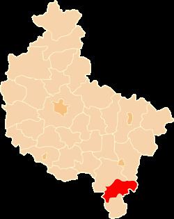
Ostrzeszów County (Polish: powiat ostrzeszowski) is a unit of territorial administration and local government (powiat) in Greater Poland Voivodeship, west-central Poland. It came into being on January 1, 1999, as a result of the Polish local government reforms passed in 1998. Its administrative seat and largest town is Ostrzeszów, which lies 134 kilometres (83 mi) south-east of the regional capital Poznań. The county also contains the towns of Grabów nad Prosną, lying 14 km (9 mi) north-east of Ostrzeszów, and Mikstat, 15 km (9 mi) north of Ostrzeszów.
Contents
Map of Ostrzesz%C3%B3w County, Poland
The county covers an area of 772.37 square kilometres (298.2 sq mi). As of 2006 its total population is 54,490, out of which the population of Ostrzeszów is 14,536, that of Grabów nad Prosną is 1,967, that of Mikstat is 1,840, and the rural population is 36,147.
Neighbouring counties
Ostrzeszów County is bordered by Kalisz County to the north, Sieradz County to the east, Wieruszów County to the south-east, Kępno County to the south, Oleśnica County to the west and Ostrów Wielkopolski County to the north-west.
Administrative division
The county is subdivided into seven gminas (three urban-rural and four rural). These are listed in the following table, in descending order of population.