
Country Poland Car plates POS Capital Ostrów Wielkopolski | Seat Ostrów Wielkopolski Area 1,161 km² Team ŻKS Ostrovia | |
 | ||
Gminas Total 8 (incl. 1 urban)
Ostrów Wielkopolski
Gmina Nowe Skalmierzyce
Gmina Odolanów
Gmina Ostrów Wielkopolski
Gmina Przygodzice
Gmina Raszków
Gmina Sieroszewice
Gmina Sośnie Voivodeship Greater Poland Voivodeship Points of interest Muzeum Miasta, Pałac Lipskich W Lewkowie, Park Natury, Park 600‑lecia, Park Olbrzymich Owadów | ||
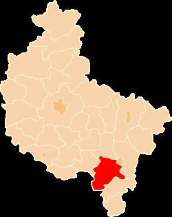
Ostrów Wielkopolski County (Polish: powiat ostrowski) is a unit of territorial administration and local government (powiat) in Greater Poland Voivodeship, west-central Poland. It came into being on January 1, 1999, as a result of the Polish local government reforms passed in 1998. Its administrative seat and largest town is Ostrów Wielkopolski, which lies 100 kilometres (62 mi) south-east of the regional capital Poznań. The county contains three other towns: Nowe Skalmierzyce, 22 km (14 mi) east of Ostrów Wielkopolski, Odolanów, 10 km (6 mi) south of Ostrów Wielkopolski, and Raszków, 8 km (5 mi) north of Ostrów Wielkopolski.
Contents
Map of Ostr%C3%B3w Wielkopolski County, Poland
The county covers an area of 1,160.65 square kilometres (448.1 sq mi). As of 2006 its total population is 158,407, out of which the population of Ostrów Wielkopolski is 72,577, that of Nowe Skalmierzyce is 5,080, that of Odolanów is 4,960, that of Raszków is 2,037, and the rural population is 73,753.
Neighbouring counties
Ostrów Wielkopolski County is bordered by Pleszew County to the north, the city of Kalisz and Kalisz County to the east, Ostrzeszów County to the south-east, Oleśnica County to the south-west, and Milicz County and Krotoszyn County to the west.
Administrative division
The county is subdivided into eight gminas (one urban, three urban-rural and four rural). These are listed in the following table, in descending order of population.