
Local time Monday 2:42 PM | Population 180 | |
 | ||
Weather 17°C, Wind W at 11 km/h, 37% Humidity Voivodeship | ||
Osinów Dolny [ɔˈɕinuf ˈdɔlnɨ] (German: Niederwutzen) is Poland's westernmost settlement, in the administrative district of Gmina Cedynia, within Gryfino County, West Pomeranian Voivodeship, in north-western Poland, on the border with Germany. It lies approximately 6 kilometres (4 mi) south-west of Cedynia, 50 km (31 mi) south-west of Gryfino, and 70 km (43 mi) south-west of the regional capital Szczecin.
Map of Osin%C3%B3w Dolny, Poland
The village has a population of 180. It is the site of a border crossing with Hohenwutzen, on the road connecting the Polish town of Chojna (formerly Königsberg in der Neumark) with Bad Freienwalde in State of Brandenburg, Germany. For more on the history of the region, see New March.
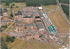
Before 1945 the area was part of Germany in the Province of Brandenburg (Frankfurt Region) within Prussia. There used to be a paper mill of minor regional importance in business here from 1936 to 1939. The paper mill was closed down; today its remaining structures are used as a marketplace.
The village enjoys a great deal of business from Germans who cross the border to purchase products and services more cheaply than in Germany. When the border crossing was opened in 1993, thousands of Germans thronged the village in search of inexpensive goods and to fill up their automobile tanks, taking advantage of the cheaper fuel rates. In recent years, it has been jokingly called "The Village of the Hairdressers" (Dorf der Friseure), due to over half of the village's inhabitants being hairdressers, mainly aimed at Germans wishing to get a cheap trim.