
Country Namibia Population 181,600 (2011) | Area 38,685 km² Team Chief Santos | |
 | ||
Time zone South African Standard Time: UTC+1 Points of interest Etosha National Park, Onguma Bush Camp, Nakambale Museum, Fort Namutoni Destinations Etosha National, Etosha pan, Okaukuejo, Tsumeb, Namutoni | ||
Oshikoto is one of the fourteen regions of Namibia, named after Lake Otjikoto near its former capital Tsumeb. The capital of Oshikoto is Omuthiya. The northern part of the region is agricultural, whereas the main economic activities in the southern part are cattle rearing and mining. The two areas have important cultural and historical links in that the Ndonga people have extracted copper at Tsumeb since the earliest times in order to make rings and tools.
Contents
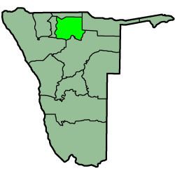
Map of Oshikoto Region, Namibia
Oshikoto is one of only three regions without either a shoreline or a foreign border. It borders the following regions:
This region comprises eleven constituencies:
Politics
Henock Kankoshi is the current governor of Oshikoto, succeeding Penda Ya Ndakolo in 2015.
The 2015 local and regional elections saw SWAPO win uncontested nine of the eleven Oshikoto constituencies. The remaining two constituencies SWAPO won by a landslide, with results well over 80%.
Economy and infrastructure
Pearl millet (Mahangu) is the principal crop in the north, while cattle are reared in the Mangetti and the Tsumeb district. Although the Tsumeb mine has only a limited life span, it can together with the associated support industries and services, provide a boost for the communal areas of the region.
Communication is good in much of the area: a paved trunk road runs across the region, linking it to both the south and the north of the country. The national microwave network terminates at Tsumeb, but telecommunications are now carried across the region and as far as Oshakati by means of a newly laid optical fiber cable.
According to the 2012 Namibia Labour Force Survey, unemployment in the Oshikoto Region is 26.4%. Oshikoto has 200 schools with a total of 60,439 pupils.
Demographics
The region's population has grown significantly over recent years, partly as a result of redistribution within the Oshiwambo-speaking area. Apart from Tsumeb and Oniipa, people have settled in a corridor along the trunk road, sometimes forming quite dense concentrations.