
Area 7.65 km² | Population (2008) 1,933 Local time Monday 9:40 AM | |
 | ||
Weather 8°C, Wind E at 10 km/h, 78% Humidity | ||
Orval is a commune in the Cher department in the Centre region of France.
Contents
Map of 18200 Orval, France
Geography
An area of lakes and streams, forestry, farming and some light industry comprising a village and a small hamlet situated some 25 miles (40 km) south of Bourges, at the junction of the D925 with the D921 and D300 roads. The river Cher forms the commune’s eastern border with the town of St. Armand. Junction 8 of the A71 autoroute is within the commune’s territory and the village is served by a TER train service.
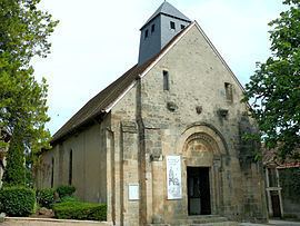
Sights
References
Orval, Cher Wikipedia(Text) CC BY-SA