
Width 1 km (0.6 mi) Highest elevation 28 m (92 ft) Elevation 28 m | Length 1.5 km (0.93 mi) Coastline 5.5 km (3.42 mi) Highest point Rambjøra Area 100 ha | |
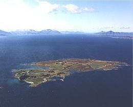 | ||
Orta is an island in Sandøy Municipality in Møre og Romsdal county, Norway. The 1-square-kilometre (250-acre) island lies midway between the islands of Harøya and Gossa in the Harøyfjorden. There are ferry connections from Orta to Sandøya and Finnøya (in Sandøy Municipality) and to Gossa (in Aukra Municipality).
References
Orta, Møre og Romsdal Wikipedia(Text) CC BY-SA