
- elevation 118 ft (36 m) | ||
 | ||
3 jeeps on flooded onesquethaw creek rd
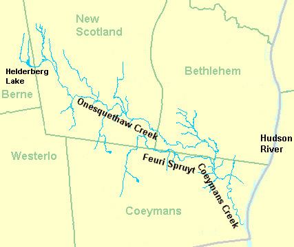
Onesquethaw Creek is a 14.5-mile-long (23.3 km) creek in Albany County, New York. It is a tributary of the Hudson River. It rises in the town of New Scotland, to the west of the hamlet of New Salem, in the Helderberg Mountains, and flows to Coeymans Creek in the town of Bethlehem, southwest of Delmar.
Contents
- 3 jeeps on flooded onesquethaw creek rd
- Map of Onesquethaw Creek South Bethlehem NY USA
- 229 900 589 onesquethaw creek road feura bush ny 12067
- HistoryEdit
- References
Map of Onesquethaw Creek, South Bethlehem, NY, USA
229 900 589 onesquethaw creek road feura bush ny 12067
HistoryEdit
O-nis'-kwe-thau Creek was also called Coeymans Creek, which continues to be the name of Onesquethaw Creek's outlet stream. There is a hamlet of this name. (Sometimes called Terrytown) in New Scotland, as well as Oniskethau flats and mountain now named Bennet Hill. It is said to have been an early Native American name meaning cornfields but this attribution was mistakenly based on William Martin Beauchamp's lack of personal knowledge of the Ma-quaes [Mohawks] language because it seemed similar to the Mahican word for maze. The Mahican's originally owned the land before it was lost to the Ma-quaes [Mohawks] during the Beaver Wars of 1628. The land was deeded to Teunis Slingerland and Johannes Apple by representatives of the three races (clans of the Ma-quaes [Mohawks] (Wolf, Bear and Turtle), owners of the land called "O-nits-quat-haa." as indicated on the original Slingerlands Land Patent Agreement. The name when translated from the Ma-quaes [Mohawk] language simply means: "Sinking-Stream." This name is much more in keeping with the actual topography of the land.