
Length 40 km | ||
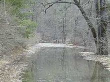 | ||
The Ompompanoosuc River /ˈɒmpɒmpənuːsək/ is a river, about 25 mi (40 km) long, in eastern Vermont in the United States. It is a tributary of the Connecticut River, which flows to Long Island Sound. According to the Geographic Names Information System, the river has also been known by the names "Om-pom-pa-noos-uc" and "Pompanoosuc."
Map of Ompompanoosuc River, Vermont, USA
The Ompompanoosuc River rises in eastern Orange County in the town of Vershire, and flows generally southwardly through the towns of West Fairlee and Thetford into northeastern Windsor County, where it joins the Connecticut River in the town of Norwich.
In Thetford the river is dammed by the Union Village Dam, which was completed in 1950 as part of a U.S. Army Corps of Engineers project for flood control. The structure is a 170-foot-high earthen dam, creating a seasonal lake in the winter.
The West Branch Ompompanoosuc River flows generally southeastwardly through the towns of Vershire and Strafford to Thetford, where it joins the main stem of the river.