
OS grid reference TQ0257 Country England Post town Woking Local time Thursday 10:20 PM District Woking UK parliament constituency Woking | Region South East Sovereign state United Kingdom Area 224 ha Shire county Surrey Dialling code 01483 | |
 | ||
Population 3,192 (Census 2011. Ward) Weather 7°C, Wind NE at 18 km/h, 81% Humidity | ||
Old Woking is a ward and the original settlement of the town and borough of Woking, Surrey, centred 1.3 miles (2.1 km) (4 km) southeast of the town centre, between Kingfield to the west and its farmland and industrial land to the east. The village has no dual carriageways or motorways and contains parts of the town's two largest parks and two converted paper mills. Its other homes are mostly semi-detached houses with gardens; its main road is the A247, a southerly access road to the A3.
Contents
- Map of Old Woking Woking UK
- History
- Manor
- After the industrial revolution
- Amenities and Localities
- St Peters Church
- St Peters church door
- Former Saint Martha Printing Works or Unwins Mill
- Gresham Mill
- Demography
- Local government
- Transport
- References
Map of Old Woking, Woking, UK
Old Woking's developed cluster is bordered on one side by Woking Park and on two sides by countryside or open buffer land including, on its southern border, the River Wey and the ruins of Woking Palace which was its manor and a royal dwelling throughout the Tudor dynasty. Having farms and an industrial area in the east of the suburb as well as lesser industry in its centre, it covers 224 hectares (550 acres).
History
The village of Old Woking, though much rebuilt due to dilapidations, predates the rest of Woking by over 1000 years and still contains many historic buildings; an architectural group of the village's Residents' Association has recorded the oldest buildings alongside officers detailing the listed buildings from English Heritage.
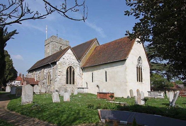
St Peters Church is a grade I listed building, dating to the 12th century, see Landmarks.
Manor
Here Woking Palace was important as a main home of Margaret Beaufort, the pious and determined mother of Henry VII. His allied forces largely obtained through his mother's marriages and skilful negotiation won the Battle of Bosworth, killing the last king to have died in battle in any part of Britain. It remained royal throughout the Tudor period however immediately from Margaret's death lost prominence to the Royal Palaces of London, briefly Oatlands Palace and Windsor Castle.
The palace had by 1911 only foundations, stumps of walls and earthwork remains. These still provide visitors with evidence its once extensive buildings, with two chapels, within a double moat. The double moat is shown in the survey by Norden of 1607, and the remains of what was the manor house are still visible at Woking Park Farm. The palace had a cornmill, a fulling-mill on the manor, and a deer park.
It was Elizabeth I's own house in 1583. James VI and I, however, made a grant of it in 1620 to Sir Edward Zouch, who died in 1634. In 1715 following that family, the palace in some ruin already, and the vast manor estate around it was bought by John Walter. His son Abel sold it to Lord Onslow in 1752 in whose hands Old Woking remained until the Earls parted with it piecemeal, through sales of part, in the 19th and 20th centuries.
After the industrial revolution
For most of the 20th Century and earlier Old Woking was the commercial hub of Woking containing many large companies including the site of the first KenWood Company, a kitchens supplier, unrelated to the similarly named Japanese company, and today part of DeLonghi.
The village has a substantive automotive sector or its economy, specifically in repair and retail. Since the 1990s most industry, storage and assembling operations have declined in the village. Thames Water's operations have expanded in line with population to the east of the village and Harvey's Water Softeners is an example of a long-established manufacturing business benefiting from patented block salts in the central industrial area. The main sites of the James Walker factory and Unwins Mill, 'the Gresham Press' operated from c.1890 until the late 20th century, the operations justified a second mill building. Both have been redeveloped into denser than average housing estates relative to the existing housing in Old Woking, however avoiding brutalist architecture, of which the ward has none and provide a suburban contrast with the 21st century rail-side apartments and especially the three 1960s originally social housing tower blocks in the centre of Woking.
Amenities and Localities
Hoebridge Preparatory School and Hoebridge Golf Course are in Old Woking. Hoebridge usually informally describes the very small locality or neighbourhood in the east.
A somewhat obscure, rarely marked name for the western network of residential roads, is the Elm Bridge Estate.
Mill Moor, directly south of the east-west High Street, is a nature reserve criss-crossed by paths, as is White Rose Lane Nature Reserve however additionally it is a Site of Special Scientific Interest.
Woking Park has two leisure complexes, one with three types of pool, including a competition pool, two main playing fields to the far east and west and has wooded garden walks. Since the early 21st century an Army Cadets, Sea Cadets and Boxing Club Headquarters is in Woking Park.
St Peter's Church
The Anglican parish church is 50 yards south of the main, relatively short east-west thoroughfare which forms the main street of the village) High Street, Old Woking) by a cluster of 17th and 18th centuries buildings around the small conservation area and very short Church Street.
St. Peter's church door
The west door to St Peter's Church, Old Woking is the oldest door in Surrey and probably the third oldest in the country having been dated by dendrochronology to the reign of Henry I (1100–35). The four planks making up the door very likely came from a single tree which was over 270 years old when it was felled. The tree must have grown from an acorn which germinated in the reign of Egbert of England (802–39).
Dr Jane Geddes of the University of Aberdeen, in her book Medieval Decorative Ironwork in England has identified the door as one of only five picture doors in the country and the ironwork as Medieval. The church is usually open after Easter in the summer months on Saturdays from 1 pm to 3 pm.
Former Saint Martha Printing Works or Unwins Mill
Surrounded by narrow channels which are corollaries of the River Wey, this imposing red-brick, tall lattice windowed former works with red stone renderings has been converted to apartments and houses.
Gresham Mill
This offshoot of the same printing works on the River Wey's backwater streams, Gresham's Mill, has also been converted to large apartments and houses; its façade is in light brick, set behind trees, with a stylistic multi-hipped, gable-end roof.
Demography
The proportion of households in Old Woking who owned their home outright was within 4% of the borough and regional average. The proportion who owned their home with a loan was 8% greater than the regional average; providing overall a lower proportion than average of rented residential property and of social housing, and close to the average in Surrey.
Local government
At Surrey County Council, one of the 81 representatives represents the area within the Woking South East division.
At Woking Borough Council. most wards of the borough are deemed appropriate to be represented under the current constitution of councillors by one councillor, which is the case for Old Woking.
Transport
The A3 has its main access to the borough from this part of Woking, less than 2.5 miles (4.0 km) away from Old Woking's centre. Other parts of Woking have their main access to a radial route out of London in the form of the M3, either via western suburbs and open countryside or north-eastern suburbs and via the M25.
The mixed use, suburban settlement is 1.3 miles (2.1 km) south-east of Woking's centre, as defined by The Peacock Centre, a large shopping mall, commencing immediately north of Woking railway station. Local roads are indirect to reach the settlement however which brings the distance to just over 2 miles (3.2 km) by road, however pedestrian and cycle shortcuts exist, mainly to cross the green buffer, Woking Park, which is a large park used for sports, play and tree-lined walks. This public recreation ground was laid out in 1906–7.
In terms of rail, as with most of the borough, the main station is Woking railway station on the South West Main Line; parking and designated foot/cycle routes are available to the relatively distant station is next nearest in any other direction, Worplesdon railway station to the south, which is on the Portsmouth Direct Line.
Buses connect: