
 | ||
The Old Annapolis Road was a planned direct route between Halifax and Annapolis Royal, the current and former capitals of Nova Scotia, in Eastern Canada. Work began in 1784, but the road was never completed, though sections remain in use today.
Contents
- Map of Old Annapolis Rd Nova Scotia Canada
- Historical context
- Geography
- Construction
- The road today
- References
Map of Old Annapolis Rd, Nova Scotia, Canada
Historical context
Annapolis Royal was the original colonial capital of Nova Scotia, until the founding of Halifax in 1749. Nevertheless, in the late 18th and early 19th century it was a commercial center and an important fortified garrison for Western Nova Scotia. It was also the principal gateway to New Brunswick by sea. Transportation between Halifax and Annapolis Royal was by a lengthy and indirect route known as the "Post Road" or "Great Western Road" which followed ancient trails from Halifax to Windsor, and then West through roads linking the Acadian settlements of the Annapolis Valley, approximately the same route is followed by Nova Scotia Highway No. 1 today. The Old Annapolis Road was an attempt to quickly connect Annapolis Royal with Halifax and open up the interior for settlement. It was the most ambitious of several roads built in the late 18th century to connect coastal settlements to Annapolis Royal. Other examples were the equally unsuccessful and identically named "Old Annapolis Road" from Shelburne to Annapolis Royal, started in 1785 but abandoned by 1814, and the more successful Liverpool to Annapolis Royal Road built in the 1790s which later grew to become Nova Scotia's Highway No. 8.
Geography
The interior of Nova Scotia consists of thick forest, extensive swamps and thin soils with only the occasional pocket of marginally fertile soil. In the early 19th century, the interior, while crossed by long-established Mi'kmaw travel routes was an uninhabited by European settlers. The route of the Halifax to Annapolis Royal road was varied to make areas of potentially-better farmland more accessible.
Work began on surveying a new road from Halifax to Annapolis Royal as early as 1776. In 1784 a new survey was conducted to plan a new route through the wilderness between the two cities, with the intention of reducing travel time - particularly for the movement of troops - and opening up the land for settlement.
Construction
Road building commenced in 1784. After a few miles had been constructed at the Western (Annapolis Royal) end of the road, work ceased. In 1816 construction resumed, with portions of the road slightly relocated to provide access of land considered more suitable for settlement. Considerable progress was made in the West, with the road reaching Sherbrooke - today known as New Ross - approximately halfway along the intended route. East of Sherbrooke, the hostile terrain proved too difficult and while the route was cleared to Halifax, construction faltered.
Some construction was completed at the Halifax end which began at the Hammonds Plains Road and which led to the Bedford Highway near Kearney Lake. Settlements by Black Refugees from the War of 1812 were successful along the first stretch of the Annapolis Road from Halifax which later became known as the Pockwock Road. West of Hammonds Plains, the road was known as the Kempt Town Road after General James Kempt who tried to complete the road in the 1820s. The road provided access to a number of number of mills and lumber camps as far west as Rafter Lake. However further west, beyond Card Lake, the road was never completed or settled. The gap between News Ross and Hammonds Plains remained a bridle path for horses in the summer and for sleighs in the winter. The Nova Scotia government continued to invest annual funds to complete the road as late as 1829. While the road was never completed for wagon traffic, it saw some use by horseback and foot traffic and for the delivery of mail between Halifax and Annapolis in the first part of the 19th century. In 1828, a 63 year old widow from Westport, Brier Island named Margaret Davis walked from Annapolis Royal to Halifax along the old Annapolis Road to resolve a land dispute and obtain a deed for her family's land on Brier Island.
The road today
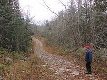
Sections of the western end of the road remain in use from Annapolis Royal to New Ross, which follows approximately the same route as that surveyed in 1784 and includes communities that grew along the road such as West Dalhousie, Dalhousie Road, the Forties Settlement and New Ross. Sections of the Eastern construction still exist as the alignment of several local road segments such as the Pockwock Road and the Kempt Town Road (sometimes now referred to as the Camp Town Road) as well as logging roads and trails. Some original road alignments and roadbed of the Old Annapolis Road have been identified by archaeologists along the Hammonds Plains Road. One section of the road near Halifax was developed by the Bowater Mersey Paper company as the Old Annapolis Road Hiking Trail and has been popular with hikers, although it was abandoned by the paper company in 2012.