Kalpana Kalpana (Editor)

Ohio State Route 29

Updated on
Edit
Like
Comment
Share on FacebookTweet on TwitterShare on LinkedInShare on Reddit
Existed:
  
1924 – present

Length
  
165.7 km

West end:
  
SR 67 near Celina

Constructed
  
1924

Ohio State Route 29

East end:
  
US 40 in West Jefferson

Counties
  
Mercer County, Ohio, Auglaize County, Ohio, Shelby County, Ohio, Champaign County, Ohio, Madison County, Ohio

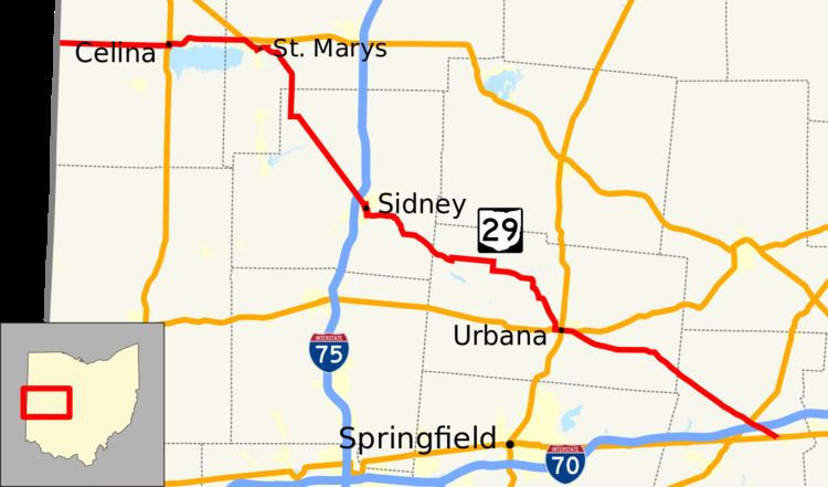
State Route 29 (SR 29) is an east–west state highway in the west-central portion of the U.S. state of Ohio. Its western terminus is at the Indiana state line near Celina, where State Road 67 continues west. It continues east to St. Marys where it junctions with U.S. Route 33. In that town, it also crosses State Route 66, State Route 116, and State Route 703, which was its former alignment before a divided highway was built. After turning south it crosses State Route 219 in New Knoxville and then has an interchange with Interstate 75, continuing into Sidney where it meets State Route 47. Still going southeast, it briefly joins State Route 235 before turning east and then south again to enter Urbana. Here the route joins U.S. Route 36, and the concurrency intersects with U.S. Route 68 and State Route 54. From there, State Route 29 leaves U.S. Route 36 and continues to Mutual, intersecting with State Route 161, and State Route 56 shortly after; later, in Mechanicsburg, the route intersects with State Route 4. The route then intersects with State Route 38, U.S. Route 42, and Interstate 70 before reaching its eastern terminus at U.S. Route 40 on the western edge of West Jefferson.

Contents

Map of OH-29, Ohio, USA

History

  • 1924 – Original route established. Originally routed along the current alignments of State Route 571 from the Indiana state line in Union City to 1-mile (1.6 km) east of Greenville, U.S. Route 36 from 1-mile (1.6 km) east of Greenville to Urbana, and its current alignment from Urbana to 2 miles (3.2 km) west of West Jefferson.
  • 1932 – The route was truncated at Urbana; alignment from Union City to Greenville designated as State Route 71; Greenville to Urbana designated as U.S. Route 36.
  • 1939 – The route was extended to the Indiana state line along the former State Route 54 alignment (which was State Route 32 before 1938).
  • 1973 – Divided highway alignment constructed from Celina to State Route 364 and freeway alignment constructed from State Route 364 to U.S. Route 33; former alignment designated State Route 703.
  • References

    Ohio State Route 29 Wikipedia