
Area 46,075 km² | ||
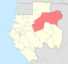 | ||
The Ogooué-Ivindo province is the northeastern-most of the nine provinces of Gabon. The regional capital is Makokou, which is home to one-third of the provincial population. It gets its name from two rivers, the Ogooué and the Ivindo. This province is the largest, least populated, and least developed of the nine.
Contents
Map of Ogoou%C3%A9-Ivindo, Gabon
The southern part of the province is crossed by the Equator. Its length runs from 11 E to 14 E and the width 0.35 S to 1 N.
To the northeast and east, Ogooué-Ivindo borders the Sangha and Cuvette-Ouest departments of the Republic of the Congo. Domestically, it borders the following provinces:
Departments
Ogooué-Ivindo is divided into 4 departments:
Historical population
The population from 1981 to 1991 lost one-fifth of the total 1981 population and the density was heading to below 1/km².