
Peak Fidlův kopec | Elevation 680 m (2,230 ft) Area 580 km² | |
 | ||
The Oderské vrchy is a mountain range in the Czech Republic, which is a part of the Bohemian Upland. It is the most Eastern part of the Sudeten Mountains, which is located fully in Czech territory and are frequently stated to be part of the Nízký Jeseník Range. The highest peak is Fidlův kopec at 680 metres.
Map of Oderske Vrchy, 785 01 Libav%C3%A1, Czechia
They create a slight upland in the Eastern Sudetes Mountains, not faraway from Olomouc and Ostrava. To the East they border the Moravian Gate, to the West and North West they border the Nízký Jeseník Range, to the South they border the basin valley of the river Bečva, while in the North they end near Opava and Ostrava.
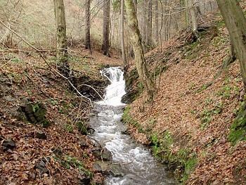
In the Oderské vrchy is the source of the river Oder, the second longest river in Poland.
Surrounding the mountains are located the cities: Olomouc, Ostrava, Opava, Odry and Bílovec.
The area of the mountains is a military territory, Vojenský újezd Libavá military training, this area not counting the trails to the source of the river Oder, is not open to tourists visitors.