
Area rank 56th Elevation 963 m Peak Karpinsky Glacier | Highest elevation 963 m (3,159 ft) Area 14,170 km² | |
 | ||
October Revolution Island (Russian: Остров Октябрьской Революции, Ostrov Oktyabrskoy Revolyutsii) is the largest island of the Severnaya Zemlya group in the Russian Arctic.
Contents
Map of October Revolution Island, Krasnoyarsk Krai, Russia
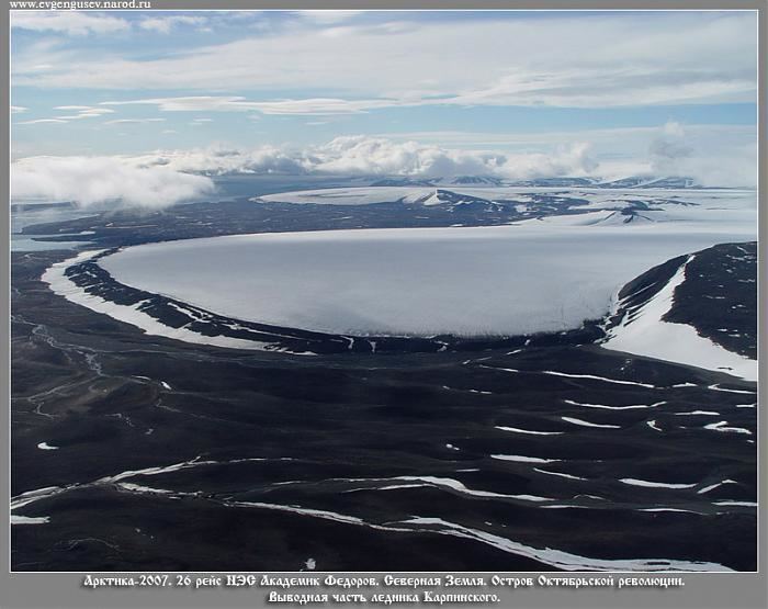
The area of this island has been estimated at 14,170 km2 (5,470 sq mi) making it the 56th largest island in the world. It rises to a height of 965 m (3,166 ft) on Mount Karpinsky. Half the island is covered with glaciers reaching down into the sea. In the sections free from ice, the vegetation is desert or tundra.
Geography
October Revolution Island houses five domed ice caps; clockwise from north, they are named: Rusanov, Karpinsky, University, Vavilov and Albanov. The Rusanov and Karpinsky ice caps, located on the eastern side of the island, feed with glaciers the Matusevich Fjord of the Laptev Sea and the Marat Fjord of the Shokalsky Strait. The Karpinsky ice cap reaches a maximum height of 963 m and it is also the highest point in Severnaya Zemlya.
Other minor ice caps on the island include the Malyutka Glacier. The Podemnaya River and the Bolshaya River drain to the northwest between the Vavilov and Albanov glaciers, and the Bedovaya and Obryvistaya Rivers drain to the north between the Albanov and Rusanov ice caps.
The coast of the island is uneven with rugged coves and headlands. The largest bays of the island are along the northern coast. The Red Army Strait separates October Revolution Island from Komsomolets Island to the north and from Pioneer Island in the northwest, while the broader Shokalsky Strait separates it from Bolshevik Island to the south. Both straits connect the Kara Sea in the west with the Laptev Sea in the east. Cape October is located in the northern part of the island facing the Red Army Strait.
History
The island was discovered by Boris Vilkitsky in 1913 during an expedition on behalf of the Russian Hydrographic Service, but its insularity wasn’t proven until 1931, when Georgy Ushakov and Nikolay Urvantsev charted the archipelago during their 1930–32 expedition.
The Vavilov Meteorological Station was operated from 1974 to 1988 on the northern part of the Vavilov Ice Cap.