
Operator ISRO SATCAT no. 35931 Bus IRS Inclination 98.27° Period 1.7 hours | COSPAR ID 2009-051A Mission duration 5 years planned Launch date 23 September 2009 Inclination 98.27° | |
Launch mass 960 kilograms (2,120 lb) Similar Oceansat‑1, SCATSAT‑1, Resourcesat‑1, Megha‑Tropiques, IRS‑1D | ||
Interactive classification of temporary settlement from vhr satellite image
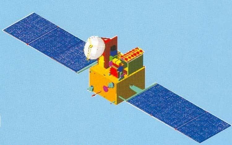
Oceansat-2 is an Indian satellite designed to provide service continuity for operational users of the Ocean Colour Monitor (OCM)instrument on Oceansat-1. It will also enhance the potential of applications in other areas. The main objectives of OceanSat-2 are to study surface winds and ocean surface strata, observation of chlorophyll concentrations, monitoring of phytoplankton blooms, study of atmospheric aerosols and suspended sediments in the water.
Contents
- Interactive classification of temporary settlement from vhr satellite image
- Mission
- Payload
- Current status
- References
Oceansat-2 is ISRO’s second in the series of Indian Remote Sensing satellites dedicated to ocean research, and will provide continuity to the applications of Oceansat-1 (launched in 1999). Oceansat-2 will carry three payloads including an Ocean Colour Monitor (OCM-2), similar to the device carried on Oceansat-1. Data from all instruments will be made available to the global scientific community after the post-launch sensor characterization, which is expected to be completed within 6 months of the launch. Oceansat-2 was launched from Satish Dhawan Space Centre on 23 September 2009 using PSLV-C14 .
Mission
The mission objectives of Oceansat-2 are to gather systematic data for oceanographic, coastal and atmospheric applications. The main objectives of OceanSat-2 are to study surface winds and ocean surface strata, observation of chlorophyll concentrations, monitoring of phytoplankton blooms, study of atmospheric aerosols and suspended sediments in the water.
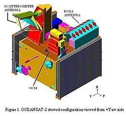
Oceansat-2 will carry two payloads for ocean related studies, namely, Ocean Colour Monitor (OCM) and Ku-band Pencil Beam Scatterometer. An additional piggy-back payload called ROSA (Radio Occultation Sounder for Atmospheric studies) developed by the Italian Space Agency (ASI) is also proposed to be included. The major applications of data from Oceansat-2 are identification of potential fishing zones, sea state forecasting, coastal zone studies and inputs for weather forecasting and climatic studies.
Payload
The scientific payload contains three instruments. Two are Indian and one is from the Italian Space Agency.
Current status
During 2007, the flight model OCM payload electronics was realised, the camera assembly was in progress and scatterometer configuration was finalised. Fabrication of mainframe systems like Core power, RF systems BMU, and sensors had started and DC-DC converters for OCM, earth sensor, TME realized.
As of 2008, mainframe structure had been realised. Preliminary design review of all mainframe systems completed. OCM camera test and evaluation had been completed. Scatterometer qualification model hardware had been realized. ROSA interfaces with spacecraft systems had been finalised. Qualification model of scatterometer scan mechanism and the interface test with electronics had also been completed.
India successfully launched its 16th remote-sensing satellite Oceansat-2 and six nano European satellites in 1,200 seconds with the help of Polar Satellite Launch Vehicle (PSLV- C-14) from Sriharikota on 23 September 2009. The launch was carried out as per schedule at 11.51 am and ended at 12.06 pm. The 44.4-metre tall, 230-tonne Indian rocket Polar Satellite Launch Vehicle (PSLV) freed itself from the launch pad at the spaceport and lifted itself up, lugging the 960-kg Oceansat-2 and the six nano satellites all together weighing 20 kg.
In copybook style, the rocket first flung out Oceansat-2 at an altitude of 720 km above the earth in a sun-synchronous orbit (SSO), followed by the four nano satellites - also called Cubesats, each weighing one kg. The remaining two, each weighing eight kg, were attached to the rocket's fourth stage. Of the six nano satellites, four are from Germany, one is from Switzerland and one from Turkey. The seventh is a big one, India's Oceansat-2 weighing 960 kg. Soon after the satellites were put into orbit, Indian Space Research Organisation's (ISRO) satellite tracking centres started monitoring them. This was the 16th PSLV mission.
Oceansat-2 was successfully deployed to predict the landfall and mitigate the effects of Cyclone Phailin. The scanning scatterometer on Oceansat-2 has been dysfunctional since February 2014.