
Elevation 1,907 m | Local time Wednesday 3:32 AM | |
 | ||
Weather 2°C, Wind S at 2 km/h, 93% Humidity Points of interest Hinterer Seelenkogel, Schalfkogel, Firmisanschneide, Hochfirst, Naturpark Ötztal | ||
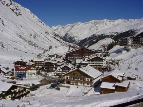
Obergurgl is a village in the Ötztal Alps in Tyrol, Austria. Located in the municipality of Sölden, the village has approximately 400 year-round inhabitants, and is mainly a tourist resort.
Map of 6456 Obergurgl, Austria
At an elevation of 1,930 m (6,330 ft), Obergurgl is the highest parish in Austria. The parish church was consecrated in 1737, and in 1967 extensions were added based on plans by Clemens Holzmeister.
Obergurgl forms part of the ski resort area of Obergurgl-Hochgurgl and lies at the southern end of the Ötztal Gurglertal valley, the longest side valley off the Inntal valley. It is a popular hiking area during the summer, with hanging valleys to the east that lead over into the Italian province of South Tyrol. There are numerous peaks over 3,500 m (11,500 ft) and several glaciers, which offer the more adventurous hikers a challenge.
There is a breeding establishment for Haflinger horses in the village, which is owned by the Scheiber family, who also own the Hotel Edelweiss & Gurgl.
Obergurgl became famous in 1931, when the Swiss explorer Auguste Piccard was forced to land on the nearby Großer Gurgler Ferner glacier during his historic balloon flight, during which he became the first man to fly into the stratosphere.