
OS grid reference SU158261 Post town SALISBURY Dialling code 01722 | Sovereign state United Kingdom Postcode district SP5 | |
 | ||
Nunton is a small village and former civil parish in Wiltshire, England, about 2.5 miles (4.0 km) southeast of Salisbury. The former parish included the small village of Bodenham, 0.6 miles (0.97 km) to the east.
Contents
Map of Nunton, Salisbury, UK
Nunton is on the River Ebble, while Bodenham is close to the junction of the Ebble and the Hampshire Avon. The A338 primary route (linking Salisbury with the south coast) separates the two villages.
Local government
Nunton and Bodenham were a tithing of Downton parish. In the 19th century it was deemed to be a separate civil parish, then in 1934 the villages were transferred to Odstock parish.
Notable landmarks
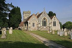
The Anglican Church of St Andrew at Nunton is Grade II* listed. It has 12th-century origins but was rebuilt in 1854-55 by T.H. Wyatt. There is a window by Christopher Webb. Nunton House, built in around 1720, is also Grade II* listed.
North of Bodenham is the Longford Castle estate, seat of the Pleydell-Bouverie family, Earls of Radnor. There is a 15th-century thatched pub at Nunton, the Radnor Arms.