
- summer (DST) CEST (UTC+2) Area 6.65 km² | Elevation 628 m | |
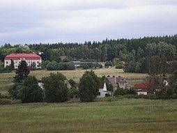 | ||
Nový Žďár (German: Neuenbrand) is a small border village in Karlovy Vary Region, Czech Republic; it is one of the districts of Aš. In 2001 the village had a population of 24.
Contents
- Map of NovC3BD C5BDC48FC3A1r 352 01 AC5A1 Czechia
- Geography
- History
- The name of the village
- Landmarks
- References
Map of Nov%C3%BD %C5%BD%C4%8F%C3%A1r, 352 01 A%C5%A1, Czechia
Geography
Nový Žďár lies 2,5 kilometres south from Aš, about 628 meters above sea level. It neighbour with Aš to the north and with Nebesa to the east. To the west there is the German border. Most of the surrounding area is covered by forests.
History
Nový Žďár was first mentioned in 1569, as a feudatory of the Zedtwitz.
The name of the village
In Czech, Nový means New. Word Žďár is from žďárovat, which means burn out the roots
Landmarks
References
Nový Žďár Wikipedia(Text) CC BY-SA