
Country Canada Time zone EST (UTC−5) Area code(s) 418 and 581 Area 173.7 km² Local time Monday 4:53 AM | Constituted January 3, 1976 Postal code(s) G0X 1W0 Highways Route 367 Population 747 (2011) Province Québec | |
 | ||
Weather -11°C, Wind SW at 0 km/h, 75% Humidity RCMs Mauricie, Mékinac Regional County Municipality | ||
Notre-Dame-de-Montauban is a municipality in the Mauricie region in Canada. This municipality is located at the northern edge of regional county municipality of Mékinac Regional County Municipality and the administrative region of Mauricie. It includes the population centres of Notre-Dame-des-Anges and Montauban-les-Mines. Both communities are located along route 367, about 7 kilometres (4.3 mi) apart.
Contents
- Map of Notre Dame de Montauban QC Canada
- Geography
- Local Economy
- Municipal timeline
- Demographics
- References
Map of Notre-Dame-de-Montauban, QC, Canada
Today, tourist activities, and the resort are significant. With the marked trails for recreational vehicles (snowmobile, ATV ...), the hunting, fishing and forest walks attract many visitors. Nine out of the fall of the Batiscan River is the major tourist attraction. On the west bank, the municipality has built a beautiful park, with a gateway to reach a large rock in the middle of the fall.
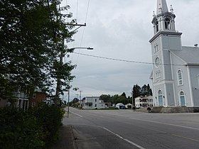
At Notre-Dame-de-Montauban, the population is approximately 850 inhabitants, with a median age of 45 years. The most significant age group is 25-44. In summer season, the population double because of the country cottages. The town has two Catholic places of worship, the church of Notre-Dame-des-Anges (Our Lady of the Angels) and the chapel of Montauban.
The Sports Centre Jules Paquin inc (Arena), located at 505 Avenue des Loisirs, Notre-Dame-de-Montauban, so designated in recognition to Jules Paquin, a businessman in the lumber industry, school commissioner, mayor and county prefect. The sports center was built in 1982 and renovated in 2011. While the "Maison des jeunes Index Inc", is located nearby, at 515 Avenue des Loisirs.
Geography
The municipality covers 163.53 km² and has 53 lakes. Batiscan river flowing from north to south, divides the city in two. The village of Notre-Dame-des-Anges is located on the east side of the river, downstream from the breathtaking falls new. While the village of Montauban-les-Mines is located in the East, near the limit of Saint-Ubalde, Quebec. The village of Notre-Dame-de-Montauban is part of the Batiscanie, Quebec, being in the watershed Batiscan River. However, an area at the southeast of the municipal territory, at the limit of Saint-Ubalde, Quebec, is rather dependent on the watershed Sainte-Anne River.
Local Economy
The railway from Hervey-Jonction to Chambord (Lac Saint-Jean) has contributed greatly to the economic growth of Notre-Dame-des-Anges sector. The railway station was built on the West side of Batiscan River.
Historically, the local economy was mainly based on agriculture and forestry. The agricultural zone occupies about 8% of the municipal territory in the area, nearly 44% is cultivated and 51% in oak. Some pastures are also intended for breeding cattle. While Montauban-les-Mines area experienced an economic boom in the mining industry, since the beginning of 20th Century.
In the history of Notre-Dame-de-Montauban, 34 sawmills have been identified. "Scierie Montauban" (Montauban sawmill) turns to be the major business in the area and only sawmill to survive. Other local SMEs operating specialize in construction, mechanical equipment and cabinetry.
Municipal timeline
Demographics
Population trend:
Private dwellings occupied by usual residents: 373 (total dwellings: 712)
Mother language of Sainte-Thècle's citizens: