
Developer(s) Horizons Aviation Stable release 7.01 / November 2009 Available in English | Initial release May 15, 2003 Operating system Type Flight planning | |
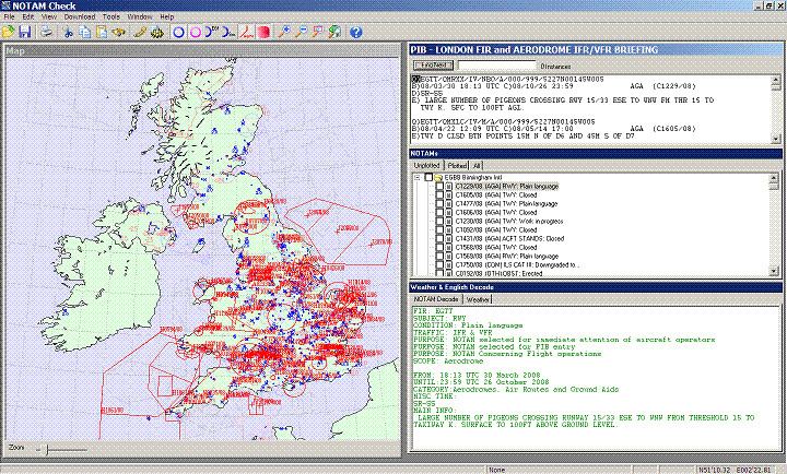 | ||
Notam Check is a software product of Horizons Aviation and is used as part of the flight planning process by pilots. Its function is to download and plot ICAO compliant Notams on to a map of the UK and France. The pilot can then select plotted Notams from the interactive map to access information and also to read an English language translation of the Notam abbreviated and coded text.
Contents
Features
Notam Check has had regular updates, the current version of Notam Check has these notable features:
True shape of Notam plotted
Although Notams have no ICAO recommended format for geographical co-ordinates apart from a circular area of influence, they do have a section called the E line which allows an English text description of the Notam. While this description is intended for a human to read and understand, it is difficult for software to decipher the near infinite number of ways to describe an area. Notam Check uses proprietary algorithms and fuzzy logic to plot the English E line descriptions.
English decode of Notam text
An ICAO compliant Notam is heavily coded and its E line description can be abbreviated almost to non readable text. Notam Check has a large database of ICAO abbreviations which it substitutes and then displays the Notam description text as complete words in English.
The coded part of the Notam, Q line to D line is also decoded in full and presented as easy to read English.
User route overlay
A user defined flight route can be overlaid onto the map to help visualise Notams of concern or to help plot an alternative route around them. The route waypoints can be made of a combination of latitude and longitude coordinates, VOR, NDB, aerodromes or British Gliding Association waypoints.
Flight Log
Once a user defined flight route has been entered, entering additional information for each route leg such as true airspeed, winds aloft and local magnetic variation allows Notam Check to calculate distance, wind correction angle and estimated time of arrival for each leg.
Weather download and English decode
TAFs and METARs are also downloaded and the abbreviations are decoded into full English.
Compatibility
Notam Check is available for all versions of Windows including Windows 95 and later. Notam Check running on Windows 95, Windows 98 and Windows Me have reduced colour graphics but functionality remains the same. Users on Windows Vista may have to reduce Internet Explorer 7 default security settings to allow Notam Check to fully access the internet.