
Population 3,578 (2011 census) Postcode(s) 5085 Founded 2000 | Established 2000 State electorate(s) Torrens Postal code 5085 | |
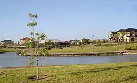 | ||
Northgate is a suburb north-east of Adelaide, South Australia. A petition was made in 1998 in a joint venture between the State Government and AVJennings to develop the area and annex it from the existing suburb of Northfield. It was formally created in June 2000. It is approximately a 10-minute drive from the Adelaide City Council area and is currently undergoing the second stage of development on land previously owned by the South Australian Department of Agriculture.
Contents
Map of Northgate SA 5085, Australia
The suburb itself is bounded by Grand Junction Road to the north, Fosters Road to the East, Folland Avenue to the South and Dumfries Avenue and Westbrook Avenue to the west. Until March 2016, Northgate also included a significant portion of what is now Lightsview.
Places of interest
Shopping
The Northgate Village Shopping Centre is located on the corner of Fosters Road and Folland Avenue and contains a Woolworths supermarket and some specialty stores.
Transport
Main roads within Northgate which are major public transport routes are:
Main North Road and Hampstead Road are major arterial roads, in very close proximity to Northgate, with both having bus services supplying those roads.
The O-Bahn Busway is also close to Northgate, with Adelaide Metro providing a bus service that links the Adelaide city centre, the O-Bahn and Northgate.