
Length 50 km Country United States of America | Basin size 196 sq mi (510 km) | |
 | ||
Main source Confluence of Silver Creek and Duck Creek6,716 ft (2,047 m) River mouth Stanislaus River1,230 ft (370 m) Discharge Average rate:429 cu ft/s (12.1 m/s) | ||
The North Fork Stanislaus River is a 31.2-mile (50.2 km) tributary of the Stanislaus River in the central Sierra Nevada and Stanislaus National Forest of eastern California.
Contents
- Map of North Fork Stanislaus River California USA
- California whitewater rafting with oars north fork stanislaus river
- Geography
- Hydroelectricity infrastructure
- References
Map of North Fork Stanislaus River, California, USA
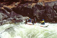
California whitewater rafting with oars north fork stanislaus river
Geography
The river flows southwest from Alpine County, through Calaveras County, to Tuolumne County.
The river begins at the confluence of Silver Creek and Duck Creek near the western edge of the Carson-Iceberg Wilderness in the Sierra Nevada. From there it flows southwest through a canyon to its confluence with the Middle Fork Stanislaus River near Forest Meadows, which forms the Stanislaus River. The river drains a mountainous, rugged watershed of about 196 square miles (510 km2).
Hydroelectricity infrastructure
Since the 1980s, the river basin has been extensively developed for hydropower generation. Water from the North Fork is stored in Alpine, Utica, Union and New Spicer Meadows Reservoirs, which regulate the water supply for McKays Point Diversion Dam, located lower down on the North Fork. From McKays Point water is diverted to the Collierville Powerhouse, which can generate up to 253 megawatts.