
Population 3,873 (2011 Census) Civil parish North Elmsall Sovereign state United Kingdom UK parliament constituency Hemsworth | OS grid reference SE4960713634 Dialling code 01977 | |
 | ||
Region | ||
North Elmsall is a village and civil parish in the City of Wakefield district in West Yorkshire, England. It had a population of 4,093 in 2001 and 3,873 in 2011. Until 1974 it was part of Hemsworth Rural District. The parish is seven miles from Pontefract, nine miles from Barnsley and Doncaster, and eleven miles from Wakefield.
Contents
- Map of North Elmsall Pontefract UK
- History
- Governance
- Village
- Occupational history
- Population history
- References
Map of North Elmsall, Pontefract, UK
In 1887, North Elmsall was described as
North Elmsall, ry. sta. (Upton and North Elmsall), E. div. West-Riding Yorkshire, 7 miles SE. of Pontefract.History
The name 'Elmsall' is derived from the Old-English 'elm', literally meaning an elm tree, and the Anglian 'halh', meaning a nook of land or a small valley.
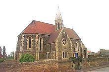
The oldest landmark in North Elmsall is St Margaret's church, on Hall Lane, which was built in 1896 and is still in use. However, an earlier acknowledgement of a settlement in this area can be found in the Domesday Book. The book lists Elmsall in the Osgodcross Hundred, with 1 villager and 5 smallholders. The total tax assessed was 8 geld units, which was very large in comparison to other Domesday settlements. Other evidence has also been found in the area of settlements dating back to the 13th or 14th century, as a medieval brooch was found in a field.
St Margaret's Church has been a Grade II listed building since 2001, giving the building a protected status by English Heritage. The church is just one of eight Grade II listed buildings in the parish, many of which date back to the 18th century. The church was designed by A H Hoole of London, and paid for by Mrs Georgina Longueville-Jones, of whom there is a marble bust in the vestry. St Margaret's also contains a memorial for those from the parish who died fighting for their country in the First World War.
Other listed buildings in North Elmsall include The Old Hall, thought to be built in around the 17th century or earlier and Lodge Farmhouse, built around 1800, and its nearby coach house and barn.
Governance
From 1894, North Elmsall was part of the Hemsworth Rural District, before its abolishment in 1974, when it became part of the Wakefield Metropolitan District. The parish is part of the Ackworth, North Elmsall and Upton ward, currently represented on the Wakefield Metropolitan District Council by three members of the Labour Party.
Village
The average house price in the parish is £236,058, and the majority of houses in the area are detached or semi-detached. Few amenities exist in the village apart from the church, but North Emsall's proximity to Upton and South Elmsall mean that services are just a short journey away. The nearest railway station is in South Elmsall, although the parish lies near to the A368, providing easy access to Wakefield, and the A628 to Barnsley.
Occupational history
In 1881, the main employment sector was agriculture, providing jobs for 53 people, 51 of whom where men. The other main type of employment at the time was domestic service, in which 22 females and 9 males were recorded to work in when the 1881 census took place. This is a typical employment structure of the time, with more men doing manual labour while women were expected to stay in the house.
From 1927, North Elmsall and nearby Upton were mining communities. The colliery closed in 1964, after numerous accidents lead to the loss of 61 lives during the 40 years it was open, as well as geological faults.
The 2011 census shows that the key areas of employment in the parish greatly differ from those of the 1881 census. Only 13 people are now employed in agriculture, despite the parish experiencing a large population growth and being located in a fairly rural area. This is likely due to the mechanisation of agricultural work, with has led to reduced dependency on manual labour, as well as improved education since the 1881 census, allowing more people to access different career paths. The main industry is now wholesale and retail trade, and many others are employed in construction and manufacturing, amongst other areas.
Population history
Census data between 1881 and 1921 shows that there were no major changes in population in the parish, with the population steadily growing from 287 in 1881 to only 462 in 1921. However, over the next ten years, the population grew rapidly, with the 1931 census listing the population as 2,368. This could be attributed to the opening of the nearby Upton Colliery, which, at the time, provided jobs for many people, attractive more people to the area. The population dropped in the 1961 census, which can again be linked to the local colliery, which closed around this time, forcing people to move away to find new employment. The population was recorded in the 2011 census as 3,873.