
Region Hong Kong Time zone Hong Kong Time (UTC+8) Area 168 km² | Constituencies 16 Website North District Council | |
 | ||
Points of interest Shing Mun Reservoir, Yuen Yuen Institute, North District Park, Hong Kong Golf Club, Pat Sin Leng Country P | ||
North District (Chinese: 北區; Cantonese Yale: Bāk Kēui) is the northernmost district of the 18 districts of Hong Kong. It is located in the northwestern part of the New Territories. The new town of Fanling-Sheung Shui is within this district. It had a population of 298,657 in 2001. The district has the second lowest population density.
Contents
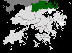
- Map of North District Hong Kong
- Demographics
- Islands of the district
- Miscellaneous
- Transport
- MTR Stations
- Border crossings
- References
Map of North District, Hong Kong
It borders with Shenzhen city with the Sham Chun River. Most major access points to Mainland China from Hong Kong lie in this district. The North District is about 168 km² in area.
Demographics
According to statistics, 70% of the population lives in the public estates in the new town of Fanling-Sheung Shui. 40,000 villagers living around the two centres and another two rural towns Sha Tau Kok and Ta Kwu Ling, account for almost all residents in the district.
Islands of the district
Miscellaneous
The northern end of the Wilson Trail hiking path is located in the North District. The trail ends at Nam Chung.
Transport
North District is served by MTR East Rail Line, Fanling Highway, San Tin Highway and Sha Tau Kok Road.