
Existed: 1921 – present Length 68.9 km | Constructed 1921 | |
 | ||
Counties | ||
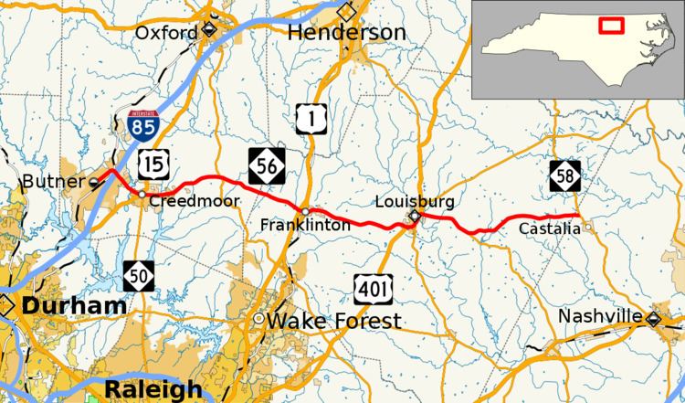
North Carolina Highway 56 (NC 56) is a primary state highway in the U.S. state of North Carolina. The primarily rural route travels east from Butner to NC 58 north of Castalia. The route connects several major towns in both Franklin and Granville counties including Creedmoor, Franklinton and Louisburg.
Contents
Map of NC-56, North Carolina, USA
NC 56 was originally routed from NC 50 in Creedmoor to NC 90 in Nashville. Between 1924 and 1930, NC 56 was truncated to NC 58 in Castalia and extended US 15 in Creedmoor after it was truncated to US 1 near Franklinton. In 1974 the route was extended west to its current terminus in Butner.
Route description
NC 56 is a predominantly two-lane rural highway connecting the three counties of Granville, Franklin and Nash. Acting as a spur route, it begins at the intersection of Central Avenue/C Street, in Butner, and goes northeast to connect with Interstate 85 (exit 191). Going southeasterly, it enters Creedmoor and has two brief concurrencies with US 15 and NC 50. Going in an easterly direction, it crosses NC 96, in Wilton, halfway before reaching Franklinton, where it connects with both US 1 and US 1A. Continuing east for 8.5 miles (13.7 km), it reaches Louisburg, where it has another short concurrency with US 401 and NC 39 along Bickett Boulevard. At the intersection of East Nash Street, NC 56 begin its concurrency with NC 581 to Mapleville. Continuing east for another 9.3 miles (15.0 km), it reaches its eastern terminus at NC 58, just over the Franklin/Nash county line and north of Castalia.
Dedicated and memorial names
NC 56 features one dedicated stretch of highway.
History
NC 56 is an original state highway that traversed from NC 50, in Franklinton, to NC 90, in Nashville. In 1923, it was extended west on new primary routing to Wilton, then northwest to NC 75, in Hester. Briefly from 1924-1925, NC 56 was truncated north of Castalia, replaced temporarily by NC 58. In 1929, NC 56 was truncated back to US 1/NC 50, in Franklinton; its routing west becoming secondary roads. In 1930, NC 56 was truncated again and its current eastern terminus at NC 58, north of Castalia; its old alignment was replaced again by NC 58 to Nashville. Also same year, NC 56 was extended west to US 15/NC 75, in Creedmoor.
Between 1947-1949, NC 56 was rerouted onto new bypass east of downtown Louisburg (today Bickett Boulevard), its old alignment along South Main Street and East Nash Street was downgraded to secondary roads (SR 1229 and SR 1231 respectively). In 1974, NC 56 was extended to its current western terminus in Butner, an upgrade to Butner-Creedmoor Road (SR-1111). In 1975, NC 56 was rerouted back through downtown Louisburg, via South Main Street and East Nash Street; it is unknown when it was reverted onto Bickett Boulevard.