
Existed: 1930 – present Constructed 1930 | Length 151.6 km | |
 | ||
Counties Columbus County, North Carolina | ||
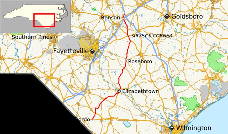
North Carolina Highway 242 (NC 242) is a primary state highway in the U.S. state of North Carolina. It traverses from Cerro Gordo to Benson, connecting the cities of Bladenboro, Elizabethtown, and Roseboro.
Contents
- Map of NC 242 North Carolina USA
- Route description
- History
- Roseboro truck route
- Roseboro alternate spur
- References
Map of NC-242, North Carolina, USA
Route description
NC 242 is a 94.2-mile (151.6 km) long rural highway that goes from US 76 in Cerro Gordo, to I-40, near Benson. It passes through Columbus, Bladen, Cumberland, Sampson and Johnston Counties. Some major cities, and towns it goes through are Cerro Gordo, Bladenboro, Elizabethtown, Roseboro, Spiveys Corner and Benson.
Although it passes through the southeastern tip of Cumberland County, it never goes near Fayetteville.
History
NC 242 was established in 1930 as a new primary route between NC 24, in Roseboro, and NC 60, in Beamans Crossroads. In 1937, NC 242 was extended south as new primary routing to US 701/NC 41/NC 53, near Elizabethtown. In 1940, NC 242 was rerouted at Salemburg north to US 421, its old alignment became Odom Road (SR 1323). Around 1946, NC 242 was extended southwest as new primary routing to NC 410, in Bladenboro. In 1948, NC 242 was extended to its current southern terminsu at US 76, in Cerro Gordo. In 1952, NC 242 was extended north to NC 50, in Benson. In 1988, NC 242 was extended north, through Benson, to its current northern terminus at I-40.
Roseboro truck route
North Carolina Highway 242 Truck (NC 242 Truck) is a short 1-mile-long (1.6 km) truck route through Roseboro, via Pinewood Street and East Street.
Roseboro alternate spur
North Carolina Highway 242 Alternate (NC 242A) was established in 1939 as a new alternate spur, creating a cutoff between NC 242 and NC 24, in Roseboro. It is unclear when NC 242A was decommissioned, from its still appearing on Sampson County maps as late as 1968, to links of missing documents located on NCDOT's website, indicated it may have been as late as 1977. Today it is East Roseboro Street.