
Existed: 1928 – present Constructed 1928 | Touristroutes: Grassy Island Crossing Length 170.4 km | |
 | ||
Major cities | ||
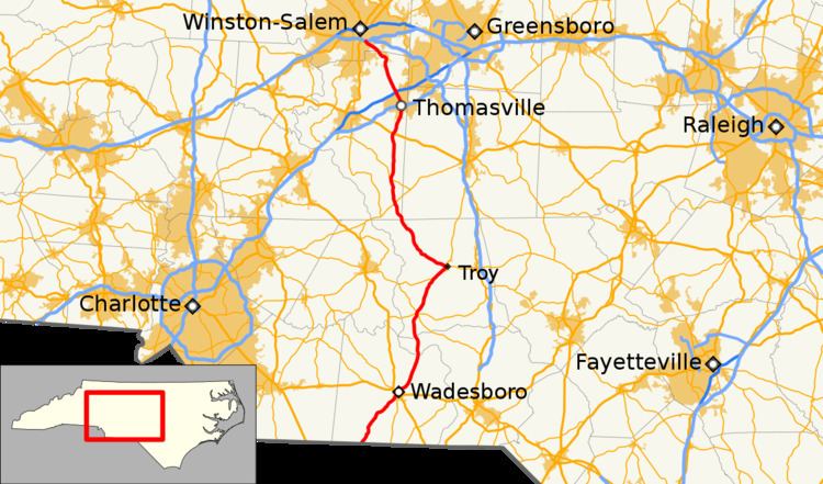
North Carolina Highway 109 (NC 109) is a north–south state highway in North Carolina. It primarily connects small towns in the central Piedmont region of the state. The 117-mile (188 km) route is a two-lane road for most of its length, but the segment between Winston-Salem and Thomasville is being upgraded to a divided 4-lane highway. The central segment of NC 109 passes through the Uwharrie Mountains and the Uwharrie National Forest.
Contents
- Map of NC 109 North Carolina USA
- Route description
- North Carolina Highway 515
- Future
- Mount Gilead business loop
- Troy alternate route
- Troy business loop
- Thomasville alternate route
- Thomasville business loop
- References
Map of NC-109, North Carolina, USA
Route description
North Carolina Highway 109 begins at the North Carolina-South Carolina border north of Ruby, South Carolina. NC 109 intersects its first road, Long Pine Church Road (Secondary Road 1220 or SR 1220) about a mile north of the border. NC 109 continues north from there to Wadesboro. NC 109 enters Wadesboro on Camden Road. The road intersects NC 742 and runs a short concurrency with the road. In downtown Wadesboro NC 109 intersects US 52/US 74/NC 742. NC 109 continues north from the intersection out of Wadesboro along N Greene Street. As the road goes further to the north it crosses the Pee Dee River into Richmond County.
After crossing into Richmond County NC 902 intersects Grassy Island Road (SR 1148). The road passes through the rural area going almost directly north towards Mount Gilead. The last intersection along NC 109 in Richmond County is with Jack Currie Road, right before the road heads into Montgomery County.
NC 109 enters rural Montgomery County and continues towards the north. When the road enters Mount Gilead on Wadesboro Boulevard it intersects NC 731 and then bypasses downtown. As NC 109 comes around the north side of Mount Gilead it intersects NC 73 and then leaves the town. About a mile after leaving Mount Gilead the road enters the Uwharrie National Forest. NC 109 intersects NC 24/NC 27 inside the national forest. NC 109 runs a concurrency with NC 24/NC 27 until Troy. In Troy NC 109 turns left to continue back north along N Bilhen Street. NC 109 crosses the Uwharrie River before going through Eldorado and entering Randolph County. NC 109 enters and leaves Randolph County within a half a mile and then enter Davidson County.
North Carolina Highway 515
North Carolina Highway 515 (NC 515) was established as a new primary routing from NC 51, in Mount Gilead, to NC 74, three miles (4.8 km) to the northwest. In 1928, NC 515 was extended south to US 74/NC 20 in Wadesboro. The road was extended to its final southern terminus at the South Carolina state line. In 1934, most of NC 515 was renumbered to NC 109. The only part that was not renumbered to NC 109 was the segment from NC 74 to NC 51; which became part of NC 73.
Future
NCDOT conducted a project study to improve the safety of NC 109 between Thomasville and Winston-Salem in 2012. Various improvements were identified, including the use of the Superstreet concept.
Mount Gilead business loop
North Carolina Highway 109 Business (NC 109 Bus) was established between 1963-1968 as a renumbering of NC 109, via Allenton Street (overlapped with NC 731) and Main Street (overlapped with NC 73). Its designation is hidden or unmarked as it only appears in state and county maps.
Troy alternate route
North Carolina Highway 109 Alaternate (NC 109A) was established around 1950-1953 as a renumbering of mainline NC 109, which was placed on a new bypass alignment west of Troy. The route traverses on Albemarle Road, West Main Street, North Main Street, Smitherman Street and Eldorado Street.
Troy business loop
North Carolina Highway 109 Business (NC 109 Bus) was established in 1960 as a rebannering of NC 109A through downtown Troy; has changed little since.
Thomasville alternate route
North Carolina Highway 109 Alaternate (NC 109A) was established in 1936 as a new alternate routing of NC 109 along Fisher Ferry Road and Main Street.
Thomasville business loop
North Carolina Highway 109 Business (NC 109 Bus) was established in 1960 as a rebannering of mainline NC 109A. In 1971, mainline NC 109 was aligned on new road further east; its old alignment along Denton Road was downgraded to secondary road, thus NC 109 Bus was decommissioned as a result.