
Country United States Time zone Pacific (UTC-8) Elevation 12 m Population 9,545 (2013) | Incorporated 1903 Area code(s) 541 Zip code 97459 Local time Friday 5:29 AM | |
 | ||
Weather 4°C, Wind S at 11 km/h, 100% Humidity | ||
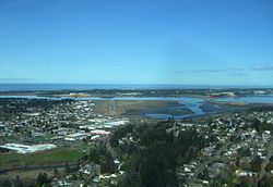
Coos bay north bend oregon
North Bend is a city in Coos County, Oregon, United States with a population of 9,695 as of the 2010 census. North Bend is surrounded on three sides by Coos Bay, an S-shaped water inlet and estuary where the Coos River enters Coos Bay and borders the city of Coos Bay to the south. North Bend became an incorporated city in 1903.
Contents
- Coos bay north bend oregon
- Map of North Bend OR 97459 USA
- 66642 east bay dr 39 north bend oregon
- History
- Geography
- Climate
- 2010 census
- 2000 census
- Museums and other points of interest
- Tribal government
- Education
- Media
- Air
- Bus
- Road
- Taxi
- References
Map of North Bend, OR 97459, USA
66642 east bay dr 39 north bend oregon
History
Before Europeans visited the Oregon coast, Native American tribes claimed the Coos Bay region as their homeland for thousands of years. Members of the Coos, Lower Umpqua, Siuslaw and Coquille tribes lived, fished, hunted and gathered along Coos Bay and its estuaries, along rivers, and in meadows and forests.
Approximately 400 years ago, British and Spanish explorers first approached the South Coast. In 1579 Sir Francis Drake is purported to have sought shelter for his ship, the Golden Hinde, around Cape Arago. Trader and explorer Jedediah Smith was in the region seeking furs and the Hudson's Bay Company sent Alexander Roderick McLeod to search for an inland passage.
The 1852 stranding of the schooner Captain Lincoln on the North Spit and the survivors' encampment and rescue brought attention to gold prospectors who came to mine placer from area beaches. In 1853 The Coos Bay Commercial Company arrived from the Rogue Valley and created routes for settlers.
Empire City was established and was the county seat of government until 1896. Entrepreneurs were drawn to the area's ample natural resources, and sawmills and shipyards at Old Town North Bend and Empire City spurred economic development and attracted workers. Rivers and sloughs provided a means to transport people, forest, agricultural and coal products, and towns provided hubs for inland transportation. Some of the early industries in the area included timber harvesting, shipbuilding, farming, coal mining and salmon canning.
Prior to around 1915, The Coos region was largely isolated from the rest of Oregon due to difficulties in crossing the Coast Range and fording rivers, and the Pacific Ocean was used to link people to other areas, including San Francisco, which was an easier two-day trip compared to traveling inland over rugged terrain. In 1916 trains were established that linked the region to other interior settlements and towns, which increased commercial trade and tourism
Significant urban growth occurred in the 1920s, and during the 1930s to 1950s large-scale growth occurred. Per the Oregon Bay Area Chamber of Commerce, during the 1930s to 1950s:
Shipyards contracted with the U.S. Government to build minesweepers and rescue tugs for World War II defense purposes. Large national lumber companies set up operations and expanded significantly for the next two decades. Jetty improvements, commercial fishing and crabbing shaped the development of Charleston. The completion of the North Bend Bridge (now McCullough Memorial Bridge) in 1936 and the Roosevelt Highway significantly improved modern transportation connections and provided the final link in opening the Coos region to the outside world. The formerly remote district known as the Coos Bay country had come of age.
During the interregnum of despair between Franklin Roosevelt's election and his inauguration, the only bank in North Bend, the First National, was forced to temporarily close its doors, precipitating a cash-flow crisis for the City of North Bend. The city solved this problem by minting currency using myrtlewood discs printed on a newspaper press. These coins, in denominations from 25 cents to $10, were used to make payroll and the city promised to redeem them for cash as soon as it became available.
However, when the bank reopened and the city appealed for people to bring their myrtlewood money in to redeem it, many opted to keep their tokens as collector's items. After several appeals, the city gave up and announced that the tokens would remain legal tender in the city of North Bend in perpetuity. Until the 1960s, people occasionally did cash in their tokens, but the remaining pieces have become very valuable through scarcity and historical interest. Fewer than 10 full sets are believed to exist.
Geography
According to the United States Census Bureau, the city has a total area of 5.09 square miles (13.18 km2), of which 3.92 square miles (10.15 km2) is land and 1.17 square miles (3.03 km2) is water.
Climate
The climate in North Bend and surrounds can be described as a very humid version of the Mediterranean climate or a dry-summer version of an oceanic climate. There is very little temperature variation throughout the year, with monthly means ranging from 46.4 °F (8.0 °C) in December to 60.1 °F (15.6 °C) in August, though on the rare occasions continental air masses penetrate they can be much more extreme, with the lowest on record being 13 °F (−11 °C) on December 21, 1990. Conversely, the record high is 100 °F (38 °C), set on June 24, 1925. Cool breezes off the Pacific moderate the city's climate year round. Rain is abundant in winter, due to moist low pressure troughs from the Pacific Ocean. The city's annual rainfall is about 64.7 inches (1,643 mm), but totals are less than an inch in July and August. Fog often blankets the coastal fringe in summer due to the temperature gradient between the cool Pacific Ocean and the warm inland, which serves to keep temperatures markedly cooler than in Eugene or even Seattle. Snow almost never falls in the city, but can be heavy in the adjacent Oregon Coast Range. Nearby Cape Blanco is one of the windiest places on Earth, with gusts of 125 miles per hour (201 km/h) or more achieved during severe winter storms. Annually, the city sees 25 days that fail to reach 50 °F (10 °C) and just 12 days with a temperature of freezing or lower.
2010 census
As of the census of 2010, there were 9,695 people, 4,113 households, and 2,495 families residing in the city. The population density was 2,473.2 inhabitants per square mile (954.9/km2). There were 4,450 housing units at an average density of 1,135.2 per square mile (438.3/km2). The racial makeup of the city was 89.3% White, 0.3% African American, 2.3% Native American, 1.7% Asian, 0.2% Pacific Islander, 1.3% from other races, and 4.9% from two or more races. Hispanic or Latino of any race were 5.8% of the population.
There were 4,113 households of which 28.7% had children under the age of 18 living with them, 43.9% were married couples living together, 12.4% had a female householder with no husband present, 4.4% had a male householder with no wife present, and 39.3% were non-families. 30.8% of all households were made up of individuals and 13.6% had someone living alone who was 65 years of age or older. The average household size was 2.33 and the average family size was 2.87.
The median age in the city was 41.3 years. 21.9% of residents were under the age of 18; 8.8% were between the ages of 18 and 24; 23.3% were from 25 to 44; 28.2% were from 45 to 64; and 17.6% were 65 years of age or older. The gender makeup of the city was 47.6% male and 52.4% female.
2000 census
Per the 2000 census, there were 9,544 people, 3,969 households, and 2,556 families residing in North Bend and the population density was 2,445.7 people per square mile (944.9/km²). There were 4,291 housing units at an average density of 1,099.6 per square mile (424.8/km²). The ethnic statistics for the city were 92.49% White, 0.38% African American, 1.79% Native American, 1.31% Asian, 0.34% Pacific Islander, 1.03% from other races, and 2.67% from two or more races. Hispanic or Latino of any race were 3.71% of the population.
There were 3,969 households out of which 30.9% had children under the age of 18 living with them, 49.8% were married couples living together, 11.5% had a female householder with no husband present, and 35.6% were non-families. The statistics for how many male householders without a wife present was not recorded by the 2000 Census. 30.1% of all households were made up of individuals and 13.9% had someone living alone who was 65 years of age or older. The average household size was 2.35 and the average family size was 2.91. North Bend's population dispersal was 24.6% under the age of 18, 7.9% from 18 to 24, 25.8% from 25 to 44, 24.6% from 45 to 64, and 17.1% who were 65 years of age or older. The median age was 40 years. For every 100 females there were 90.3 males. For every 100 females age 18 and over, there were 87.5 males. The median income for a household in the city was $33,333, and the median income for a family was $41,755. Male median income was $34,494 and female median income was $23,244. The per capita income for the city was $16,703. About 11.8% of families and 14.8% of the population were below the poverty line, including 20.0% of those under age 18 and 13.0% of those age 65 or over.
Museums and other points of interest
North Bend is near ocean beaches, including the Oregon Dunes National Recreation Area, which has camping sites, and outdoor recreation opportunities such as all-terrain vehicle driving on the dunes. The Oregon Dunes Recreation Area begins just north of North Bend and attracts approximately 1.5 million visitors each year. North Bend has a public recreational boat ramp that accesses Coos Bay, along with a new concrete pier/boardwalk area that was completed in 2010 per North Bend's regional urban renewal policy. North Bend has a public Olympic-sized indoor pool. The Pony Village Mall in North Bend is a large indoor shopping mall. The Mill Casino is an Indian gaming entertainment center in North Bend with a hotel, gambling, and restaurants. The Bandon Dunes Golf Resort is about 25 miles (40 km) south of North Bend.
Sitting just outside of North Bend is the Coos History Museum, in Coos Bay. This museum was located in North Bend until a new facility was completed in 2014, and the museum and all of its contents were moved to the new location. The Coos History Museum attracts people from around the world as they pass through the area, and it holds precious information about the history of Coos County in Oregon.
Tribal government
The seat of the Coquille Indian Tribe's tribal government is located in North Bend, which is a United States recognized sovereign tribe of Native Americans who have traditionally lived on the southern Oregon Coast. The Coquille Tribe owns several businesses, including The Mill Casino and Hotel, an organic cranberry growing and packing operation in North Bend, Heritage Place assisted living center, and ORCA Communications, a telecommunications provider.
Education
The North Bend School District provides K-12 public education for residents of the area. Southwestern Oregon Community College in nearby Coos Bay offers two-year associate degrees and other academic programs.
Media
Air
The Southwest Oregon Regional Airport near North Bend and Coos Bay is the only commercial airport on the Oregon Coast.
Bus
Porter Stage Lines provides bus service from Coos Bay, Oregon with several stops, including Eugene, which has connections with Amtrak rail services and the Greyhound bus network. Porter Stage Lines ends at Ontario, Oregon in eastern Oregon, and then reverses the trip.
Road
North Bend is home to the Conde McCullough Memorial Bridge and the Haynes Inlet Bridge.
Taxi
Yellow Cab taxi company offers taxi service for all of Coos County.