
Main source Wahpoonga Range Basin size 1,948 km (752 sq mi) Mouth Pacific Ocean Country Australia | River mouth Pacific Ocean Basin area 1,948 km² Source Wahpoonga Range | |
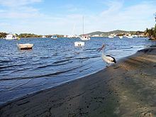 | ||
Noosa river drone footage
The Noosa River is a river situated in South East Queensland. The catchment starts in Wahpoonga Range near Mount Elliot in the coastal Great Sandy National Park and meanders south through a lakes district around Tewantin.
Contents
- Noosa river drone footage
- Map of Noosa River Cooroibah QLD Australia
- Noosa river underwater footage noosa underwater biodiversity assessment nuba
- History
- References
Map of Noosa River, Cooroibah QLD, Australia
Lakes situated on the river include Lake Cooloola, Lake Como, Lake Cootharaba, Lake Cooroibah and Lake Weyba. The catchment is mostly covered by sand dunes and has two major tributaries—Kin Kin Creek and Teewah Creek.
The Noosa River enters the Pacific Ocean at Noosa, where substantial residential development has encroached into areas previously occupied by the changing river path. The river is noted for its populations of migratory birdlife.
Noosa river underwater footage noosa underwater biodiversity assessment nuba
History
Logging along the river began in 1864. The logs were transported north to a sawmill near Maryborough until 1870 when a sawmill was built on Lake Cootharaba.
Richard Branson purchased Makepeace Island on the river in May 2003. Noosa Council scaled down his plans for a luxury resort on the river.
Several kilometers of beach to the north of the mouth were a popular destination for four-wheel driving, until the Sunshine Coast Regional Council placed restrictions on them in May 2007.
Chemical contamination has been the suspected cause of a fish mutation resulting in two-headed fish larvae found in the Noosa River. Government investigations into the problem began in 2007. A final scientific report into the cause of the spawning was delayed in 2010 because of the potential to prejudice ongoing civil court proceedings involving the hatchery and a nearby macadamia nut farm.
Until the 1960s the Noosa beach and river entrance were in a state of dynamic equilibrium. The beach was wide and usable and it recovered quickly from the occasional extreme storm events such as cyclones. From the mid 60's rapid development on the beachfront including building a rockwall along the beach created instability. The beach became narrow and often non existent at high tide. At this time the river entered the sea at the present day Noosa Woods. In 1978 a training wall was built to relocate the river entrance to the northwest where it is today.