
Country Thailand Time zone ICT (UTC+7) Area 3,027 km² Area rank Provinces of Thailand | Capital Nong Khai ISO 3166 code TH-43 Population 517,269 (2014) | |
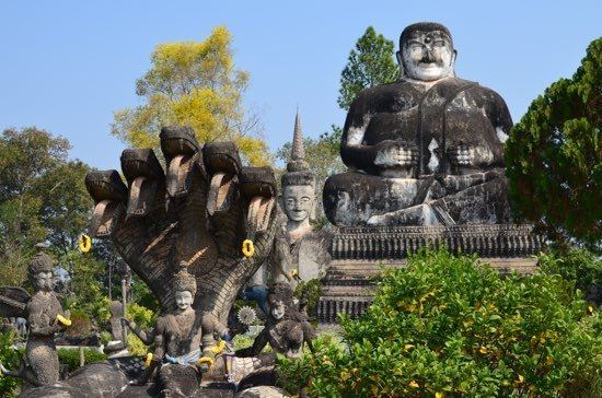 | ||
Points of interest Sala Keoku, Buddha Park, Thai–Lao Friendship Bridge, Wat Pha Tak Suea, Nong Khai Aquarium | ||
Nong Khai (Thai: หนองคาย, [nɔ̌ːŋ kʰāːj]) is the northernmost of the northeastern (Isan) provinces (changwat) of Thailand. Neighbouring provinces are (from east clockwise) Bueng Kan, Sakon Nakhon, Udon Thani, and Loei. To the north it borders Vientiane Province, Vientiane Prefecture, and Bolikhamxai of Laos.
Contents
Map of Nong Khai, Thailand
Geography
The province is in the valley of the Mae Nam Kong (Mekong River), which also forms the border with Laos. There are highlands to the south. The Laotian capital Vientiane is only 25 kilometres away from the provincial capital of Nong Khai. The Thai-Lao Friendship Bridge, which connects the two countries, was built jointly by the governments of Thailand, Laos, and Australia, and was opened in 1994.
History
Over the centuries the control of the province swung between the Thai Kingdom Ayutthaya, and the Laotian kingdom Lan Xang, as their respective powers ebbed and flowed in the region. See also the Haw wars.
Administrative divisions
As of March 23, 2011, the province is subdivided into nine districts (amphoe). The districts are further subdivided into 62 subdistricts (tambon) and 705 villages (muban). The eight districts of Bueng Kan were districts of Nong Khai before, they were split as the newest province of Thailand.