
Location Pacific Ocean Major islands 2 Highest point Piu 'o Tafahi Elevation 560 m Archipelago Geography of Tonga | Total islands 3 Highest elevation 560 m (1,840 ft) Largest settlement Hihifo, Niuatoputapu Area 71.69 km² | |
 | ||
Niua is a division of the Kingdom of Tonga, namely the northernmost group of islands. It consists of three islands (Niuafoʻou, Niuatoputapu and Tafahi) which together have an area of 71.69 km2 and a population of 1,282. The largest village is Hihifo on Niuatoputapu. Piu'o Tafahi is the highest point with an elevation of 560 m.
Contents
Map of Niuas, Tonga
Geography
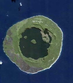
The islands are the peaks of undersea volcanoes, towering from the sea, some of which were still active until very recently.
History
The Niua group was discovered in 1616 by Willem Schouten and Jacob Le Maire Cornelisz during their circumnavigation with the ships and Eendracht Horn to Europe.
References
Niuas Wikipedia(Text) CC BY-SA