
Native name 錦川 Basin size 885 km (342 sq mi) Basin area 885 km² | River mouth Seto Inland Sea Length 110 km Source Shunan | |
 | ||
Main source Shūnan, Yamaguchi, Japan | ||
Japan travel iwakuni castle iwakuni city yamaguchi 02 moopon nishiki river mountain castle
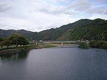
The Nishiki River (錦川, Nishiki-gawa) is a 110 km long river, the longest in Yamaguchi Prefecture, Japan. The Nishiki is the main river in a larger system measuring 331.8 km in total. The government of Japan classifies it as a second-class river system. The Nishiki River system drains an area of 884.2 km².
Contents
- Japan travel iwakuni castle iwakuni city yamaguchi 02 moopon nishiki river mountain castle
- Map of Nishiki River Iwakuni Yamaguchi Prefecture Japan
- References
Map of Nishiki River, Iwakuni, Yamaguchi Prefecture, Japan
The Nishiki River has its source in the city of Shūnan. At its mouth in the part of the city of Iwakuni that was formerly the separate town of Nishiki, it drains into the Inland Sea.
References
Nishiki River Wikipedia(Text) CC BY-SA