
Country Thailand Time zone ICT (UTC+7) Geocode 2108 Population 32,482 (2005) | Seat Nikhom Phatthana Postal code 21180 Area 237.5 km² Province Rayong Province | |
 | ||
Nikhom Phatthana (Thai: นิคมพัฒนา, [ní(ʔ).kʰōm pʰát.tʰā.nāː]) is a district (amphoe) of Rayong Province, eastern Thailand.
Contents
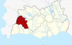
Map of Nikhom Phatthana District, Rayong, Thailand
History
The minor district (king amphoe) was established on 15 July 1996 by splitting four tambon from Ban Khai District.
Following a decision of the Thai government on 15 May 2007, all 81 minor districts were upgraded to full districts. With publication in the Royal Gazette on 24 August, the upgrade became official.
Geography
Neighboring districts are (from the north clockwise) Pluak Daeng, Ban Khai, Mueang Rayong, and Ban Chang of Rayong Province, and Bang Lamung of Chonburi Province.
Administration
The district is subdivided into four sub-districts (tambon), which are further subdivided into 30 villages (muban). Map Kha is a township (thesaban tambon) which covers parts of tambon Nikhon Phatthana and Map Kha. Also the town Map Ta Phut, centered in Mueang Rayong District, covers parts of tambon Map Kha as well. There are further four tambon administrative organizations (TAO) responsible for the non-municipal areas.