
Country Japan Website www.niikappu.jp Local time Tuesday 12:58 AM | Area 585.9 km² | |
 | ||
Time zone Japan Standard Time (UTC+9) Weather 0°C, Wind NW at 6 km/h, 95% Humidity Points of interest Niikappudeikazan, Niikappucho Kyodo Museum, Mount Esaoman-Tottabetsu, Mount Idonmappu | ||
Niikappu (新冠町, Niikappu-chō) is a town located in Niikappu District, Hidaka Subprefecture, Hokkaido, Japan.
Contents
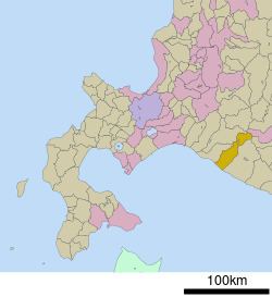
- Map of Niikappu Niikappu District Hokkaido Prefecture Japan
- History
- Geography
- Economy
- Art and Culture
- Transportation
- References
Map of Niikappu, Niikappu District, Hokkaido Prefecture, Japan
History
The town was established September 1881.
Geography
Niikappu stretches from the Pacific Ocean of southeast Hokkaido north to the Hidaka Mountains along the Niikappu River. The town covers a total area of 585.88 km². Its highest point is Mount Poroshiri and the lowest is at the coast. The town runs 45 kilometres (28 mi) East-West and 44 kilometres (27 mi) North-South
Economy
The town is mainly known for production of racehorses, including Haiseiko, Narita Brian, and Oguri Cap.
Art and Culture
Niikappu has a large collection of records.
Other features of Niikappu include:
Transportation
References
Niikappu, Hokkaido Wikipedia(Text) CC BY-SA