
Admin. region Köln Elevation 304 m (997 ft) Population 10,625 (31 Dec 2010) | Time zone CET/CEST (UTC+1/+2) Local time Monday 8:35 AM | |
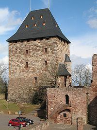 | ||
Weather 3°C, Wind S at 6 km/h, 76% Humidity Points of interest Burg Nideggen, Wildpark Schmidt, Burgenmuseum, Rur, Panzerkette Kall Trail | ||
Nideggen is a town in the district of Düren in the state of North Rhine-Westphalia, Germany. It is located on the river Rur, in the Eifel hills, approx. 15 km south of Düren.
Contents
Map of 52385 Nideggen, Germany
Nideggen is known for its ruined, but partly restored castle (Burg Nideggen) and the sandstone rocks along the Rur. It is twinned with Thatcham in Berkshire, England. The first mention in history was in 1184.
The town was created in 1972 by amalgamation of eight until then independent communities: Abenden (782 inhabitants), Berg-Thuir (709), Brück (301), Embken (734), Muldenau (161), Nideggen (2.983), Rath (757), Schmidt (2.974), Wollersheim (637) (December 2014). It is situated between 250 and 450 metres above sea level.
Geographical position
Nideggen lies on the river Rur and at the banks of the Rurtalsperre, the second largest dam in Germany. The region is famous for its precipitous Early Triassic rocks of Buntsandstein in the valley of Rur and is situated between 250 and 450 metres over sea level.